


- Browse Categories
- YQFH Drone
- DJI Drone
- Other Drone
- Drone Payloads
- Robot
- Pipeline Detection Instrument
- 3D Laser Scanner
- Industrial Measurement Devices
- Weather Station Series
- Optical Survey Instruments
- GNSS RTK & CORS System
- BDS System Products
- Visual Displacement Monitoring System
- UWB Indoor Positioning System
- Hydrology Products
- Others
- Spectrometer
- Wet Blast Machine
- SDI Soil Tester
- Pengjin Smart Flying Drone Patrol and Inspection System
- Supercomputing
- Module
- Viscometer
- Electric Hygro-thermograph
- Echo Sounder
- Processing Software
- Keson Measuring Tools
-
-
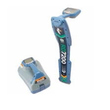
Radiation Detector Locator RD7200
The new RD7200 is an uncompromising, all-industrial locator designed for accurate and effective daily use.More
-
-
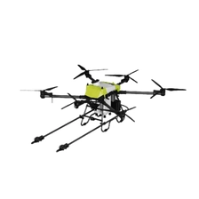
Cleaning Drone (Customization Available)
Rinsing Water Pressure: 12–15 MPa
More
Cleaning Flow Rate: 8–10 L/min
Cleaning Flight Speed: 0.1–0.3 m/s (Vertical Flight)
Cleaning Flight Duration: 5–7 min (Onboard Water Supply); 9–12 min (Ground Water Supply)
Cleaning Efficiency: 9–27 m²/min
-
-
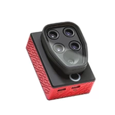
Parrot SEQUOIA+ Unmanned Aircraft Systems multispectral sensor for agricultural drone camera
The Parrot Sequoia+ multispectral sensor is revolutionising the sector, offering a comprehensive, adaptable solution that is compatible with all types of drones. With its two sensors, multispectral and sunshine, Parrot Sequoia+ analyses plants' vitality by capturing the amount of light they absorb and reflect. Collecting this data means that farmers can do what's best for their fields.
More
-

-
Terrestrial penetration radar GPR of PVC pipe King Low -cost deep gold
The wireless land penetration penetration radar (GPR) of the DZLD-6000 of GPR. It also adds functions such as wireless transmission, hardware and software filtering, variable gain in time, software delay, adjustable software sampling, standard communication protocol IEEE80 2.11, automatic parameter configuration and other functions. It is easy to use and does not need adjustment. At the same time, the land penetration equipment with WLAN works as screen and storage, such as laptop, tablet, etc., and more than 14 hours can work in a continuous period.
More
-
-
Cheap Chinese Brand Price 336 555 800 Channels FOIF A90 GPS RTK GNSS
With a high-tech, fully integrated design, the convenient size A90 is one of the most flexible options for any measurement task. It comes preloaded with multiple smart applications such as the built-in Linux 3.2.0 operating system, tilt surveying, electronic bubble calibration, NFC, and voice DIY. The A90 Plus RTK GPS ROVER system provides surveyors with industry-leading GPS ROVER operations.
More
-
-
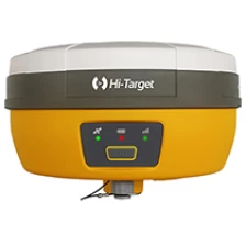
High Target Efficient and Convenient Survey V30 Plus GNSS RTK System
The V30Plus features a built-in multi-contelected GNSS engine with a small, industrial-grade compact design, providing a flexible GNSS working solution. It is also integrated with WebUI, WiFi, Bluetooth and 4G modules, making data management and transmission more convenient and faster. With HI Target's professional site research software and up to 10 hours of work hours, V30Plus meets user needs in an efficient and convenient research experience.
More
-
-
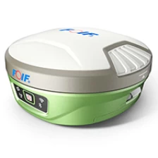
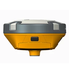
Hot Sale Surveyor Base and Rover GPS High Target V90 Plus GPS GNSS RTK Receiver
With a high-tech, fully integrated design, the affordable size V90Plus is one of the most flexible options for any measurement task. Preloaded with multiple smart applications such as built-in Linux 3.2.0 operating system, tilt surveying, electronic bubble calibration, NFC, and voice DIY, the V90Plus GNSS system offers the surveyor industry's leading GNSS solution.
More
-
-
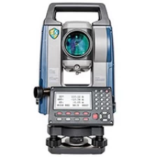
Professional high-precision engineering total station SOKKIA IM100 series
The IM-100 (Intelligent Measurement Total Station) incorporates all the necessary features at a cost-effective price. Meet the needs of the most demanding research layouts and completed projects.
More
-
-
Original best price KP-90N digital koizumi planimeter MAP types digital planimeter
The most standard model of "PLACOM" N-Series has made the excitingly highest attainment in the history of Planimeter ever made. Measuring capacity is remarkably enlarged. Measuring by 6-digit pulse count enables to measure 100 times larger accumulative area than ordinary planimeters. Easy calculations of Cumulative and Average Value Measurement. Conversion of Unit and Scale value is made by easy operation. "WONDER", it is a most worthy word to be given to this "PLACOM" N-Series.
More
-
-
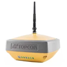
topcon rtk gps hyper vr gnss receiver
Hyper VR: High-tech and versatile GNSS receiver
With its compact and robust design, the HiPer VR is packed with cutting-edge GNSS technology.
More
-
-
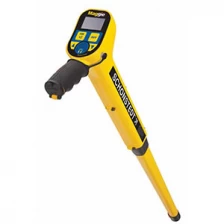
GA-92XTd Radiodection Schonstedt Magnetic Metal Locator
Fully automated SuperSting™ has been thoroughly field-tested in every extreme environment on the planet and is used in over 700 peer-reviewed journal articles, with the highest accuracy and lowest noise levels in the industry It will achieve this. The SuperSting™ series of electrical resistivity tomography equipment is the industry's first multi-channel feature and is being continuously improved and updated with additional features.
More
-
-
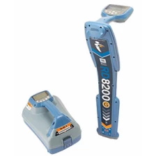
Radiodetection SPX RD8200 most advanced precision locators. ground locator driven best on-site practise pipeline detector
RD8200 Locator Specification
Product Descriptions
Multi-purpose Precision Locator
Cable and Pipe Locator
Locate System Receiver
Multi-function Precision Locator
More
