


- Browse Categories
- YQFH Drone
- DJI Drone
- Other Drone
- Drone Payloads
- Robot
- Pipeline Detection Instrument
- 3D Laser Scanner
- Industrial Measurement Devices
- Weather Station Series
- Optical Survey Instruments
- GNSS RTK & CORS System
- BDS System Products
- Visual Displacement Monitoring System
- UWB Indoor Positioning System
- Hydrology Products
- Others
- Spectrometer
- Wet Blast Machine
- SDI Soil Tester
- Pengjin Smart Flying Drone Patrol and Inspection System
- Supercomputing
- Module
- Viscometer
- Electric Hygro-thermograph
- Echo Sounder
- Processing Software
- Keson Measuring Tools
Category
-
-
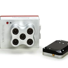
MicaSense Sensor RedEdge-MX Multispectral Camera For UAV Mapping Drone
Compact, flexible, and powerful.A rugged, built-to-last, professional multispectral sensor for agricultural drone mapping.Captures five spectral bands, and is one of the most flexible solutions on the market.A rugged, built-to-last, professional multispectral sensor for agriculturaldrone mapping. Captures five spectral bands, and is one of the mostflexible solutions on the market.More
-
-
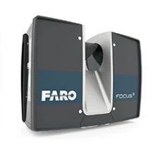
Professional Survey Faro Laser Scanner Focus S350
MoreThe FocusS 350 combines all benefits from FARO’s well-known Focus3D Laser Scanners with today’s most innovative features to perform laser scanning in both indoor and outdoor environments - truly mobile, fast and reliable. The FARO FocusS 350 provides the next level of laser scanning for all applications in industries like Construction, BIM/CIM, Public Safety and Forensics. cs.
-
-
Drone Airport (Customization Available)
Dimensions: 1.3m × 1.1m × 1.2m (Closed); 2.8m × 1.1m × 1.2m (Expanded)
More
Weight: V4.0 Charging Version approx. 220 kg; Battery-Swapping Version approx. 260 kg.
Maximum Inspection Range: NCC/FCC: 15 km; CE/MIC: 8 km; SRRC: 8 km
Operating Ambient Temperature: -20°C to 50°C
Temperature Control Method: Industrial Air Conditioning
Maximum Storage Capacity: 8 batteries (Battery Swapping Version)
Emergency Operation Time: 300 minutes
Video Transmission Latency: 0.3 seconds
Service Ceiling: 4,000 m
Standby Power: 100W
Maximum Power: 2100W
Protection Rating: IP55 (Customizable)
-
-
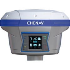
Low-cost surveying machine CHC I90 PROGNSS GPS RTK
The i90 Pro GNSS receiver combines the latest CHCNAV IMU-RTK technology with compatibility with L-band correction services to extend RTK positioning anywhere. It integrates cutting-edge GNSS RTK engine with calibration capabilities. Free high-end IMU sensors and
More
Advanced GNSS tracking features greatly increase the availability and reliability of the RTK.
-
-
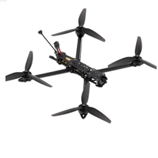
First Person View Drones YFM7-A (Customization Available)
Features:
1.New Frame design ensures reliable strength and makes flight more stable
2.Efficient 2810 motor, takeoff load weight of about 1.5kg,Max 2KG
3. The first visual flight experience, precision flight
4. Nose rectification design to increase flight efficiency
5. Larger battery compartment, convenient to put larger batteries
6. Maximum flight altitude of 5000 meters
7. Maximum flight speed 140 km/h
8. Maximum payload flight time about 7 minutes
9. No-load flight time about 20 minute
More
-
-
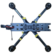
First Person View Drones (Customization Available)
Frame: LY10-A
More
Wheelbase: 435mm
Flight Controller: F405 FC
Video Transmission: RAD 2.5W
Motor: EM3115 900KV
Propellers: HQ1050
Operating Temperature: -10°C - 40°C
Receiver: Elrs915
Antenna: MOMODA 5.8GHz Antenna
GPS: M10
Camera: Caddx Ratel 2 (Removable Lens)
Recommended Battery: Lipo 6S 5600mAh with XT90 Plug
-
-
Inspection Drones+Robotic Arm (Customization Available)
Features:
High operational efficiency and time-saving and labor-saving: The inspection drone + robotic arm system enables continuous and efficient de-icing, significantly surpassing manual de-icing efforts, which are limited by physical strength and harsh environments.
Significantly improved safety: Remote control operation is achieved, eliminating the need for personnel to climb towers, fundamentally eliminating the dual risks of working at height and in freezing temperatures.
Strong ability to handle complex terrain: The inspection drone + robotic arm system is suitable for operations in narrow and rugged terrain that is inaccessible to large vehicles.
More
-
-
Performance Drone (Customization Available)
Dimensions: 318 × 350 × 136 mm
More
Diagonal Wheelbase: 232mm
Weight: 530g
Flight Time: 31–35 min
Minimum Flight Spacing: 1.5 m
Suggested Performance Duration: 10–25 minutes
Operating Temperature: -10°C to 50°C
Wind Resistance Rating: ≤ Level 5
Lighting Power: 0–20 W
-
-
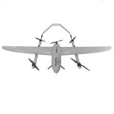
Vertical take-off and landing fixed-wing UAV (Customization Available)
Dimensions: 2500*1400*400mm
More
Material: Fiberglass
Payload: 1.5kg
Maximum Takeoff Weight: 12kg
Cruising Speed: 72km/h
Tracking Radius: 20km~50km+
Endurance: 100 minutes @ 1kg
Maximum Level Flight Speed: 30m/s
Wind Rating: Fixed Wing <= Class 6 / Rotary Wing <= Class 5
Service Ceiling: 4000m
Take-off and Landing Method: Vertical Take-off and Landing
Disassembly and Transport: Quick-disassembly, transport box
(Customizable)
-
-
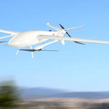
Composite wing drone (Customization Available)
Dimensions: 320*183*46mm
More
Maximum Takeoff Weight: 30kg
Maximum Payload: 5kg
Unladen Flight Time: 240 minutes
Cruising Speed: 21m/s
Maximum Altitude: 4200m
Wind Resistance: Fixed Wing <= Class 7 / Rotary Wing <= Class 6
Disassembly and Transportation: Quick Disassembly, Transport Case
Ingress Protection: IP54 (Customizable)
-
-
PJC8000 Ground Penetrating Radar
The wireless land penetration penetration radar (GPR) of the PJC8000 of GPR. It also adds functions such as wireless transmission, hardware and software filtering, variable gain in time, software delay, adjustable softwaresampling, standard communication protocol IEEE80 2.11, automatic parameter configuration and other functions. Itis easy to use and does not need adjustment. At the same time, the land penetration equipment with WLAN works as screen and storage, such as laptop, tablet, etc., and more than 14 hours can work in a continuous period
More
-
-
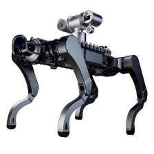
YQEX-1 Explosion-proof Robot
Intelligent BionicQuadruped Explosion-Proof Robot YQEX-1 Series
Redefining a New Line of Defensefor High-Risk Operations
More
