English
français
Deutsche
Italian
русский
Español

Shenzhen Peng Jin Technology Co., Ltd.

New Products

Who We Are?

Pengjin Technology specialized in UAV, UAV collector (multispectral camera, thermal camera, hyperspectral camera) and UAV software. The company also sells BIM (lofting robot, laser 3D scanner), BIM software; Pipeline detection instruments, pipeline tools, pipeline radar, geological radar; Meteorological products, hydrological products, laser instruments, geodetic instruments, soil hardness testing instruments, 4D deformation monitoring system, drawing measuring instruments, industrial measuring equipment, etc..
China about us manufacturer

Certificate Shows

Main Market

Customer Reference

China Micasense camera manufacturer

Micasense camera

China Topcon total station GM52 manufacturer

Topcon total station GM52

China UK SDI soil tester manufacturer

UK SDI soil tester

China Measuring Depth with a C.A.T4 manufacturer

Measuring Depth with a C.A.T4

Online Servrice

7*24 hours online,working days respond within 12 hours, rest days within 24 hours.
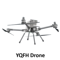
Contact Us
Linda Lin

QQ:2850187683

TM:cn220015897

Email: pjk@pjkcn.com

Tel:+8615899753550

Linda Lin

Janet luo

QQ:2850187684

TM:CN220015800

Email: pjm@pjkcn.com

Tel:+8613828792860

Janet luo

Blue Gao

QQ:2850187700

TM:CN220017749

Email: reaka@pjkcn.com

Tel:+86 135 10 45 76 25

Blue Gao

News Center
14
2022-02

AgEagle Unveils the MicaSense RedEdge-P Drone Sensor

Doubling the Resolution and Capture Rate of the Market-Leading RedEdge-MX™, and Unleashing Extensive, Highly Precise Data Analysis Capabilities for Agriculture, Forestry and Land Management Drone Programs

29
2023-12

Agriculture & Forestry

GPR sees use in high value crop management such as vineyards. The primary focus is on managing soil water content to provide optimal growing conditions. A corollary focus is on soil conditions, structure and character that affect water flow and drainage. While smart farming is a primary area of use, recreational areas such as golf course greens are another focus.

25
2023-12

Explore hardrock (kimberlites, quarry stone) and sedimentary (potash) Map stratigraphy Detect hazards for mine safety

Explore hardrock (kimberlites, quarry stone) and sedimentary (potash) Map stratigraphy Detect hazards for mine safety

21
2023-12

Geophysical surveys for Faults and Sinkholes

Engineered development and assessment of groundwater conditions demand solid definition of subsurface conditions. GPR’s ability to define geologic strata and detect anomalous geologic structure makes it a regular tool in the engineering geophysicist’s arsenal of methods. In addition, GPR is one the few methods that is directly sensitive to the water content and chemistry. Applications range from route selection for roads, railway and pipelines to karst evaluation.

14
2022-02

AgEagle Announces Launch of MicaSense’s Altum-PT

An Optimized 3-in-1 Sensor Integrating Ultra-High Resolution, Panchromatic Imaging and Thermal Imaging to Provide Unlimited Analytical Capabilities at Leaf-Level Resolution