


- Browse Categories
- YQFH Drone
- DJI Drone
- Other Drone
- Drone Payloads
- Robot
- Pipeline Detection Instrument
- 3D Laser Scanner
- Industrial Measurement Devices
- Weather Station Series
- Optical Survey Instruments
- GNSS RTK & CORS System
- BDS System Products
- Visual Displacement Monitoring System
- UWB Indoor Positioning System
- Hydrology Products
- Others
- Spectrometer
- Wet Blast Machine
- SDI Soil Tester
- Pengjin Smart Flying Drone Patrol and Inspection System
- Supercomputing
- Module
- Viscometer
- Electric Hygro-thermograph
- Echo Sounder
- Processing Software
- Keson Measuring Tools
Category
-
-
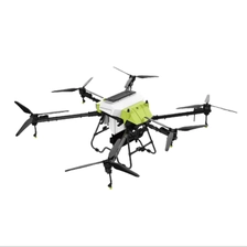
Plant Protection Drone (Customization Available)
Overall Weight: 44 kg
More
Tank Capacity: 40L
Body Dimensions: 2840 × 2680 × 890 mm
Folded Dimensions: 1290 × 760 × 890 mm
Nozzle Quantity: 6 (Self-pressurizing)
Operational Flight Speed: 1–10 m/s (Adjustable)
Spray Width: 9 m
Spray Flow Rate: 1–8 L/min
Droplet Diameter: 120–200 μm
Tank Capacity: 50 L
Number of Discharge Ports: 5
Broadcast Particle Diameter: 0.1–10 mm
Material Monitoring Method: Load Cell
Broadcast Material Types: Powders, Granules, Bran-like Substances
(Customizable)
-
-
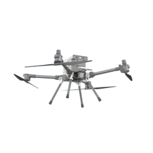
Surveying Drone (Customization Available)
Wheelbase: 990 mm
More
Empty Weight: 11 kg
Max Takeoff Weight: 17 kg
Max Payload: 6 kg
Battery: 11,000 mAh 12S × 2
IP Rating: IP55
Wind Resistance: Level 6
Operating Temperature: -20°C to 50°C
-
-
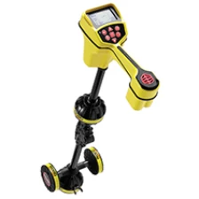
Ridgid Underground Utility Locator SeekTech SR-20 Underground Wire Locator
Ridgid's new localization equipment line meets the most demanding needs of localization professionals. What's built to make difficult locations easier, SeekTech has an omnidirectional antenna, guided arrows, easy-to-read mapping It is the only line locator that quickly guides using the display. Move to the target line.
More
-
-
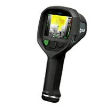
hot sale Handheld Temperature sensor flir thermal camera Flir K65
The FLIR K65 is independently certified to comply with the NFPA 1801; 2018 Edition Standard for Thermal Imagers, covering usability, image quality, and durability for firefighting.More
-
-
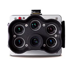
Original high-resolution panchromatic band multispectral Micasense camera Rededge-P
RedEdge-P: Capture data more quickly during the seasonSingle Camera Solution for Adjusted High-Resolution Synchronous Capture Efficient multispectral and RGB images with optimized FOV and capture rates. flight.More
-
-
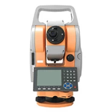
Low-cost and low-cost equipment total station PTS-1202R
Measure distance and angle with high accuracy. Excellent ranging accuracy to ensure data accuracy and reliability. Mature absolute encoding technology allows for shutdown of measurement intervals and no initialization at startup is required. Remarkable telescope, high resolution, clear and bright, high resolution of telescope system, effectively relieves eye fatigue.
More
-
-
SDI high precision digital modified roads applications hand soil compaction equipment soil hardness tester CIST/883 20 Kg
The Clegg Impact Soil Tester type CIST/882 manufactured by SD Instrumentation (SDi) provides a means for measuring and controlling soil strength and consolidation levels during trench re-instatement. It is also used to confirm uniform compaction over wide areas of ground, identifying poorly compacted areas and ineffective rolling of materials. A special lightweight version of the Tester is also available for checking sports turfs whilst a heavy duty version is supplied for testing harder materials and roadworks.
More
-
-
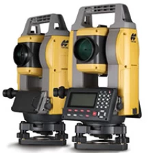
Cost-effective Topcon Total Station GM-50 Series GM52
We carry out strict environmental tests to ensure long-term operation even in harsh on-site environments. The Total Station GM series is thoroughly inspected in a dustproof and waterproof test room. Furthermore, it has passed various tests for vibration, drop, temperature and humidity, achieving the best environmental specifications. In addition, the measurement distance accuracy test at baseline and horizontal and angle accuracy tests and adjustments of the instrument using a collimator system ensure that you are satisfied with the quality of the GM series.More
Please click " more For more information, see below.
-
-
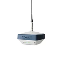
Sokia GRX3 RTK GPS
The Sokkia GRX3 GNSS receiver is a powerful satellite system packed with top-class GNSS technology built for static and kinematic land surveying applications. It features an innovative 9-axis inertia measuring unit (IMU) and an ultra-compact eCompass that keeps balance even when leveling up to 15 degrees.
More
-
-
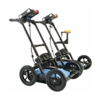
Top Quality Wireless Detection RD1100/RD1500 Underground Radar with On-Board Wi-Fi
RD1100 & RD1500 Underground radar:Innovative tools to find buried utilities It provides location experts, surveyors and other users with the tools they need to track and mark any type of location. Manufacturing cables and pipes containing plastic and ceramics. Ability to take standard built-in screenshots and save them internally Memory for immediate emails via Wi-Fi and later export to a USB memory stick. GPS positioning is obtained for integration with Google Earth™.
More
-
-
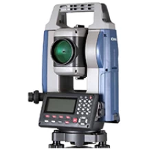
Automatic tracking high precision original surveying machine Total station Sokia IM52
iM-50 Series - Intelligence Measurement Station
• Fast and accurate positioning using phase shift technology.
More
●High-speed ranging in 0.9 seconds regardless of the target object.
• Minimum measurement distance without reflectors - only 30cm.
• Improved collimation with ultra-high brightness pointers.
• EDM beam spot size is reduced, minimizing distance measurement errors.
• Reliable measurements even at shallow angles of incidence.
• Ensures accurate reflective sheet distance measurement.
-
-
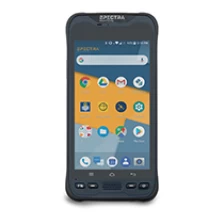
Professional Smartphone GNSS Handheld Geospatial Data Collector MobileMapper 60
MobileMapper 60 All-in-One GNSS receiver and smartphone provide the ultimate in functionality. Accuracy and convenience of handheld geospatial data collection. Because it is slim and lightweight, It has a weather-resistant design with hand straps and a large high-resolution screen, making it easy to operate. Viewing and data manipulation.
More
