


- Browse Categories
- YQFH Drone
- DJI Drone
- Other Drone
- Drone Payloads
- Robot
- Pipeline Detection Instrument
- 3D Laser Scanner
- Industrial Measurement Devices
- Weather Station Series
- Optical Survey Instruments
- GNSS RTK & CORS System
- BDS System Products
- Visual Displacement Monitoring System
- UWB Indoor Positioning System
- Hydrology Products
- Others
- Spectrometer
- Wet Blast Machine
- SDI Soil Tester
- Pengjin Smart Flying Drone Patrol and Inspection System
- Supercomputing
- Module
- Viscometer
- Electric Hygro-thermograph
- Echo Sounder
- Processing Software
- Keson Measuring Tools
Category
-
-
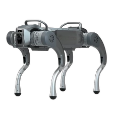
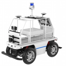
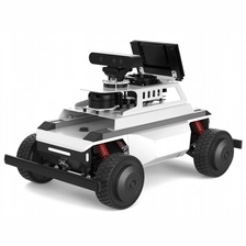
YQS1 Series Large Industrial Grade
Omni-Sense Perception,Boundless Smart Mobility
More
-
-
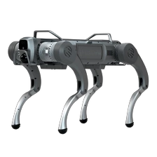
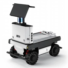
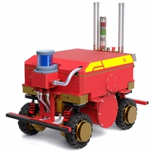
YQE1 Series Medium Industrial Grade
Breaking Boundaries Intelligent Future Creation
Application Ecosystem Leading the Embodied Intelligence Full-Scenario
More
-
-
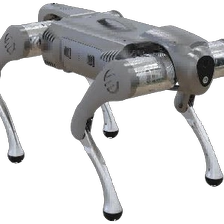
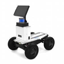
YQC1 Series Small Industrial Grade
Agile as the wind . Intelligent omnidirectional control
Embodied Al integration empowers better perception and interaction with the world
More
-
-
YQ-OS-venus Open-source Navigation Kit for Healthcare Application Exploration
Al-driven Development and ApplicationPlatform for Commercialization of MedicalPersonal, Elder Care, and Senior Living.
More
-
-
YQ-OS-saturn Apollo 3.0/7.0 Self-driving Open Source EDU Kit
-Vehicle-grade chassis and Apollo open-source code.
More
-Efficient Development and Learning Platform for Research and Education in the Field of New Energy Vehicle Autonomous Driving.
-
-
YQ-NV-magic High-precision Low-speed Level 4Commercial Autonomous Driving Kit.
Integrated Development and ApplicationPlatform for Commercialization of IndsutryEnergy, Construction, and Agriculture Scenarios.
More
-
-
YQ-OS-mate/mate2 ROS1/ROS2 3D LIDAR Open Souirce Navigation R&D KIT
- Convenient Development and LearningPlatform for Multi-Scenario Research andEducation in the Field of Vehicles and Robots.
-
-
YQ-OS-lite/lite2 ROS1/ROS2 2D LiDAR SLAM Open Source Navigation EDU Kit
- Convenient development and learning platform for autonomous navigation research and education in the fields of automotive and robotics.
-
-
YQ-OS-nano Desktop ROS Robot EDU Kit
-Lightweight portable modular structure design
More
-Robot learning application development platform for artificial intelligence development and education.
-
-
YQ-FB-IIC Exd IIC T6 Gb Elexplosion Proof 4T4D Mobile Robot Platform
-Design of IIC-class explosion-proof four-wheel drive motion structure
More
-Omnidirectional robot application developme platform suitable for Elexplosion Proof scenarios
-
-
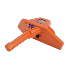
PJC18 Integrated Intelligent Pipeline Detector
- Effectively shields against external signal interference and maintains stable signal performance in complex envi ronments.
- Adopts the principle of electromagnetic induction.
- Pipeline Route & Burial Depth
-
-
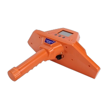
PJC28 Integrated Intelligent Pipeline Detector
- Effectively shields against external signal interference and maintains stable signal performance in complex environments.
- Adopts the principle of electromagnetic induction.
- 3D Imaging
- Beidou Positioning Function
- Pipeline Route & Burial Depth
