


- Browse Categories
- YQFH Drone
- DJI Drone
- Other Drone
- Drone Payloads
- Robot
- Pipeline Detection Instrument
- 3D Laser Scanner
- Industrial Measurement Devices
- Weather Station Series
- Optical Survey Instruments
- GNSS RTK & CORS System
- BDS System Products
- Visual Displacement Monitoring System
- UWB Indoor Positioning System
- Hydrology Products
- Others
- Spectrometer
- Wet Blast Machine
- SDI Soil Tester
- Pengjin Smart Flying Drone Patrol and Inspection System
- Supercomputing
- Module
- Viscometer
- Electric Hygro-thermograph
- Echo Sounder
- Processing Software
- Keson Measuring Tools

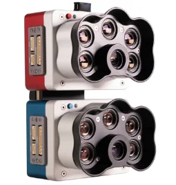
Micasnese RedEdge-P dual
Two sensors. 10 bands. For enhanced data comparison with satellites.
High-resolution multispectral and RGB composite drone sensor for plants classification, weeds identification, environmental research and conservation, and vegetation analysis of water bodies.
The dual solution features the RedEdge-P and the new RedEdge-P blue cameras.
Applications
Vegetation analysis of water bodies
Surveys over water for chlorophyll efficiency examination, vegetation analysis and identification of algae or floating, submerged and emergent plants.
Environmental monitoring
Coastal and near-shore mapping for water resources management, tidal zones, swamps and glacier monitoring.
Water management
Public water supply surveillance, water resources management.
Habitat monitoring, protection and restoration
Erosion and biodiversity inspections, reef surveys over shallow waters, inaccessible to vessels and sensitive to human interaction.
Vegetation species and weeds identification
Vegetation health management and species identification, including the ability to differentiate and count plants, trees, invasive species, and weeds.
Key features
• 10 multispectral bands at 1.6 MP each.
• Pan-sharpening technology for spatial resolution of 2 cm / 0.8 in per pixel compared to satellites at ~10 m / 32 ft.
• Coastal blue band for water vegetation analysis and weeds identification.
• Double radiometric calibration with light sensor and calibration reflectance panel for reliable data in varying light conditions.
• Global shutter on all 10 lenses for distortion-free image capture.
• Narrow bands for enhanced data accuracy.
• Fast capture rate: 3 raw DNG images per second.
• Synchronized capture of all 10-bands, automatic triggering and geotagging of images for efficient flight times easy post-processing.
Specifications
| Weight | 745 g / 26.2 oz (two sensors, mounting hardware, DLS2, and cable) |
| Dimensions | 13.2 cm x 8.8 cm x 9.67 cm / 5.1 in x 3.1 in x 3.5 in |
| Spectral bands | Coastal blue 444(28)*, Blue 475(32), Green 531(14)*, Green 560(27), Red 650(16)*, Red 668(14), Red Edge 705(10)*, Red Edge 717(12), Near-IR 740(18)*, Near-IR 842(57) |
| RGB output | 5.1 MP** (global shutter, aligned with all bands) |
| Sensor resolution |
1456 x 1088 (1.6 MP per multispectral band) 2464 x 2056 (5.1 MP panchromatic band) |
| Ground sample distance |
7.7 cm / 3 in per pixel (per multispectral band) at 120 m / ~400 ft AGL 3.98 cm / 1.5 in per pixel (panchromatic band) at 120 m / ~400 ft AGL |
| Field of view | 50° HFOV x 38° VFOV (multispectral), 44° HFOV x 38° VFOV (panchromatic) |
| Capture rate | Up to 3 images per second raw DNG |
| Storage | CFexpress card |
| Interfaces | Three configurable GPIO: select from trigger input, PPS input, PPS output, and top of frame signals. Host virtual button. USB 2.0 port for WiFi. Serial. 10/100/1000 Ethernet. |
| External power | 7.0 V - 25.2 V |
| Power input | 11/14.0/20W (standby, average, peak) |
| Heat |
Ambient without airflow: 0-40 °C / 0-104 °F Ambient with airflow >0.5 meter per second / >1.1 mph: 0-50 °C / 0-122 °F |
| IP rating | IP4X |
Tel:+8613828792860
Wechat:PJK13828792860
Contact Person:Janet luo

- Other Products


