


- Browse Categories
- YQFH Drone
- DJI Drone
- Other Drone
- Drone Payloads
- Robot
- Pipeline Detection Instrument
- 3D Laser Scanner
- Industrial Measurement Devices
- Weather Station Series
- Optical Survey Instruments
- GNSS RTK & CORS System
- BDS System Products
- Visual Displacement Monitoring System
- UWB Indoor Positioning System
- Hydrology Products
- Others
- Spectrometer
- Wet Blast Machine
- SDI Soil Tester
- Pengjin Smart Flying Drone Patrol and Inspection System
- Supercomputing
- Module
- Viscometer
- Electric Hygro-thermograph
- Echo Sounder
- Processing Software
- Keson Measuring Tools
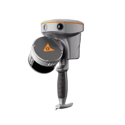
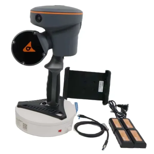
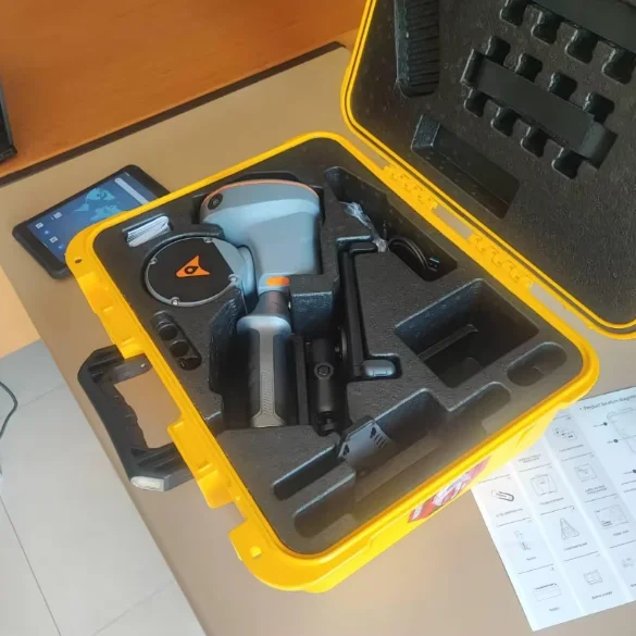
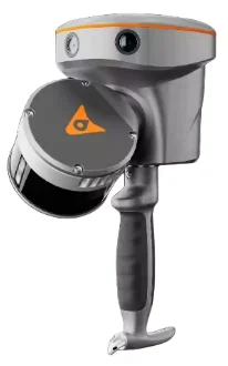
CHCNAV RS30 Innovative Handheld Surveying Slam 3D Laser Scanner Plus GNSS RTK System
- Relative accuracy:<1 cm
- Working time :1h(for a single battery)
- Data storage:512G
- Weight:1.9 kg (including RTK and battery)
- Loop-free data acquisition:Yes
- Real-time accuracy assessment:Yes

Specifications
|
General System Performance |
|
|
Absolute accuracy |
H: < 5 cm RMS |
|
Relative accuracy |
<1 cm |
|
Power supply mode |
Lithium battery, supports hot-swapping and portable charger |
|
Working time from a single battery |
1h |
|
Data storage |
512 GB |
|
Field of view |
360° × 270° |
|
Weight |
1.9 kg (including RTK and battery) |
|
Loop-free data acquisition |
Yes |
|
Real-time accuracy assessment |
Yes |
|
Laser Scanner |
|
|
Laser product classification |
Class 1 Eye Safe |
|
Range |
0.05 to 120 m |
|
Channel |
16 |
|
Point cloud thickness |
2cm |
|
Range capability |
80 m @10% reflectivity (Channels 5 to 12) |
|
FOV (Horizontal) |
360° |
|
Horizontal angle resolution |
0.18° (10 Hz) |
|
FOV (Vertical) |
30° (-15° to +15°) |
|
Max. effective measurement rate |
320,000 points/sec |
|
Selectable scan speed |
10 Hz |
|
Max. Number of return pulses |
2 |
|
Wavelength |
905 nm |
|
GNSS Performance |
|
|
Channels |
1408 channels with iStar2.0 |
|
GPS |
L1C/A, L2C, L2P(Y), L5 |
|
GLONASS |
L1, L2, L3 |
|
Galileo |
E1, E5a, E5b, E6* |
|
BeiDou |
B1I, B2I, B3I, B1C, B2a, B2b |
|
QZSS |
L1C/A, L1C, L2C, L5, L6* |
|
NavIC/IRNSS |
L5* |
|
PPP |
B2b-PPP |
|
SBAS |
EGNOS (L1, L5) |
|
GNSS Accuracies |
|
|
Real time kinematic (RTK) |
H: 8 mm + 1 ppm RMS |
|
Post-processing kinematic(PPK) |
H: 3 mm + 1 ppm RMS |
|
PPP |
H: 10 cm | V: 20 cm |
|
High-precision static |
H: 2.5 mm + 0.1 ppm RMS |
|
Static and rapid static |
H: 2.5 mm + 0.5 ppm RMS |
|
Code differential |
H: 0.4 m RMS | V:0.8 m RMS |
|
Visual-assisted positioning |
Yes |
|
IMU |
|
|
IMU update rate |
200 Hz |
|
Auto initialization |
Yes |
|
Attitude accuracy after post-processing |
0.005° RMS pitch/roll, |
|
Position accuracy |
0.010 m RMS horizontal, |
|
Camera |
|
|
Number of cameras |
3 |
|
Resolution |
15 MP (5 MP*3) |
|
Sensor size |
2592 (H) × 1944 (V) |
|
Pixel size |
2.0 µm |
|
FOV |
210° × 170° |
|
Environments |
|
|
Operating temperature |
-20°C to +50°C |
|
Storage temperature |
-20°C to +60°C |
|
Ingress protection |
IP64(5) (according to IEC 60529) |
|
Humidity (operating) |
80%, non-condensing |
|
Electrical |
|
|
Input voltage |
9 - 20 V DC |
|
Power consumption |
<30 W |
|
Battery capacity |
24.48 Wh |
|
Equipped Software |
|
|
SmartGo software |
Data acquisition control, real-time point |
|
CoPre intelligent processing software |
POS process, Adjust & Refine, Generate point cloud, modeling, etc |
|
CoProcess efficient feature extraction software |
Building feature extraction, road feature extraction, volume calculation, etc |
|
LandStar Field Survey APP |
Topographic survey, Point stakeout, Line stakeout, Elevation check, Facade survey |

- Other Products


