


- Browse Categories
- YQFH Drone
- DJI Drone
- Other Drone
- Drone Payloads
- Robot
- Pipeline Detection Instrument
- 3D Laser Scanner
- Industrial Measurement Devices
- Weather Station Series
- Optical Survey Instruments
- GNSS RTK & CORS System
- BDS System Products
- Visual Displacement Monitoring System
- UWB Indoor Positioning System
- Hydrology Products
- Others
- Spectrometer
- Wet Blast Machine
- SDI Soil Tester
- Pengjin Smart Flying Drone Patrol and Inspection System
- Supercomputing
- Module
- Viscometer
- Electric Hygro-thermograph
- Echo Sounder
- Processing Software
- Keson Measuring Tools
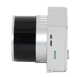
UAV LiDAR Scanning System LD-260X
- Brand Name:PJK
- Model Name:LD-260X
- Place of Origin:China
- Warranty:1 year
- Support Express:Sea freight, air freight
LD-260X is a kind of Mid-range, compact LiDAR point cloud data acquisition system, integrated HESAI Pandar XT laser scanner, GNSS and IMU positioning and attitude determination system, and storage control unit, is able to real-time, dynamically, massively collect high-precision point cloud data and rich image information. It is widely used in the acquisition of 3D spatial information in surveying, electricity, forestry, agriculture, land planning.
Specification
|
LD-260X |
||
|
|
Item Name |
System Parameters |
|
LD-260X Parameters |
Weight |
1.26 kg |
|
Measuring accuracy |
Less than 0.1m/0.05m(@150m) |
|
|
Working temperature |
-20℃~+65℃ |
|
|
Power range |
12 V- 24 V |
|
|
Consumption |
10 W |
|
|
Carrying Platform |
DJI M300, M600 PRO and Other brand |
|
|
Storage |
64 GB storage, maximum support 128GB TF card |
|
|
Lidar Unit
|
Measuring Range |
80m@10% Reflectivity (Max 300m) |
|
Laser class |
905nm Class1 (IEC 60825-1:2014) |
|
|
Channel |
32-Channel |
|
|
Range accuracy |
||
|
Scanning frequency |
10HZ, 20HZ |
|
|
data |
Trible echo 1,920,000 Points/Sec |
|
|
FOV |
360°, adjustable |
|
|
Laser sensor |
HESAI Pandar XTM2X |
|
|
POS Unit |
Update frequency |
200HZ |
|
Heading accuracy |
0.017° |
|
|
Pitch accuracy |
0.005° |
|
|
Rolling accuracy |
0.005° |
|
|
Position accuracy |
≤0.05m |
|
|
GNSS signal type |
GPSL1/L2/L5 GLONASSL1/L2 BDS B1/B2/B3 GAL E1/E5a/5b |
|
|
Pre-processing software |
POS software |
Output information: position, speed, attitude |
|
Point cloud software |
Output point cloud data format: LAS format, custom TXT format |
|
|
Camera (option) |
Camera Model |
Sony a 6000 or Other brand with same Level |
|
Effective Pixel |
24 Mega Pixel |
|
|
Trigger event |
Distance or Time trigger |
|
|
Weight (g) |
135 |
|
Please feel free to contact us if you are interested in this product.

- Other Products


