


- Browse Categories
- YQFH Drone
- DJI Drone
- Other Drone
- Drone Payloads
- Robot
- Pipeline Detection Instrument
- 3D Laser Scanner
- Industrial Measurement Devices
- Weather Station Series
- Optical Survey Instruments
- GNSS RTK & CORS System
- BDS System Products
- Visual Displacement Monitoring System
- UWB Indoor Positioning System
- Hydrology Products
- Others
- Spectrometer
- Wet Blast Machine
- SDI Soil Tester
- Pengjin Smart Flying Drone Patrol and Inspection System
- Supercomputing
- Module
- Viscometer
- Electric Hygro-thermograph
- Echo Sounder
- Processing Software
- Keson Measuring Tools
32 Channel UAV LiDAR Scanner HESAI XT Laser Sensor 3D Scanning
- Brand Name:PJK
- Model Name:LD-130X
- Place of Origin:China
- Warranty:1 year
- Support Express:Sea freight, air freight
32 Channel UAV LiDAR Scanner HESAI XT Laser Sensor 3D Scanning

|
Minimum Order Quantity : |
1 |
Price : |
Negotiation |
|
Packaging Details : |
Suit Case 530*430*240 mm |
Delivery Time : |
10-15 works days |
|
Payment Terms : |
T/T, Western Union |
Supply Ability : |
30 SETS/Month |
|
Place of Origin: |
China |
Brand Name: |
PJK |
|
Certification: |
CE, ISO |
Model Number: |
LD-130X LiDAR Scanning System |
Detail information
|
Name: |
UAV LiDAR Scanner |
Application: |
3D Scanning |
|
Channel: |
32 Channels |
Appliation: |
Power Line Patrol |
|
Sensor: |
HESAI XT Laser Sensor |
||
|
High Light: |
32 Channel UAV LiDAR Scanner HESAI XT UAV LiDAR Scanner 3D LiDAR Scanning System |
||
Product description
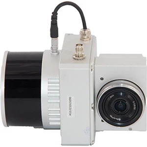
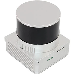
gAirHawk UAV LiDAR Scanner is a kind of short-range, compact LiDAR point cloud data acquisition system, integrated HESAI XT laser scanner, GNSS and IMU positioning and attitude determination system, and storage control unit, is able to real-time, dynamically, massively collect high-precision point cloud data and rich image information. It is widely used in the acquisition of 3D spatial information in surveying, electricity, forestry, agriculture, land planning.
Pandar XT
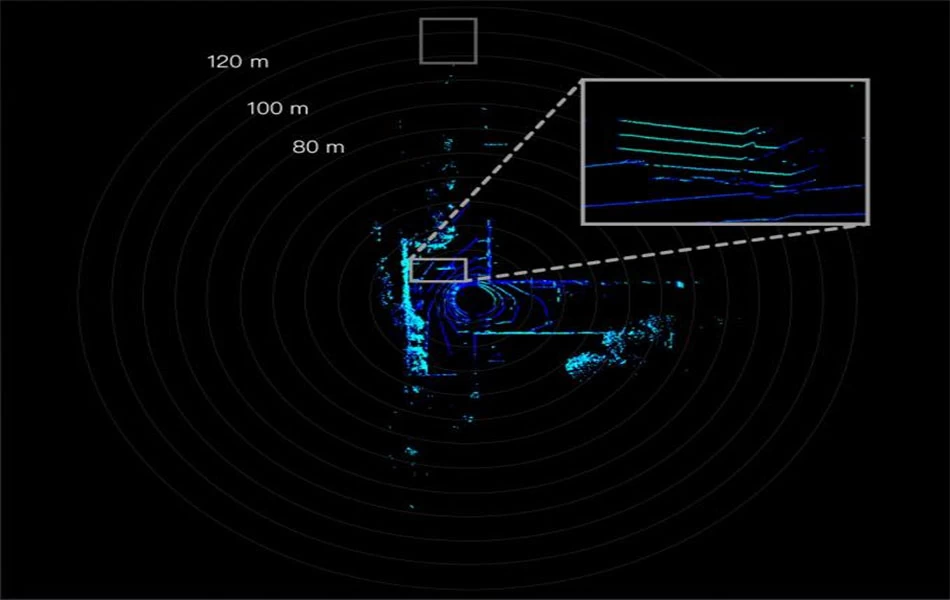
High precision. Minimum range of zero.
Proprietary LiDAR ASICs.
32-Channel Short-Range Mechanical LiDAR
Product specification
| LD-130X | ||
| Item Name | System Parameters | |
| LD-130X Parameters | Weight | 1.26 kg |
| Measuring accuracy | Less than 0.1m @120m | |
| Working temperature | -20℃~+65℃ | |
| Power range | 12 V- 24 V | |
| Consumption | 10 W | |
| Carrying Platform | LD-800 Multi Rotor and Other brand | |
| Storage | 64 GB storage, maximum support | |
| 128GB TF card | ||
| Lidar Unit | Measuring Range | 0.3m-120m@10% Reflectivity |
| Laser class | 905nm Class1 (IEC 60825-1:2014) | |
| Channel | 32-Channel | |
| Range accuracy | ±1cm (typical Value) | |
| Scanning frequency | 10HZ, 20HZ | |
| data | Double echo 1,280,000 Points/Sec | |
| FOV | 360°, adjustable | |
| Laser sensor | HESAI Pandar XT | |
| POS Unit | Update frequency | 200HZ |
| Heading accuracy | 0.017° | |
| Pitch accuracy | 0.005° | |
| Rolling accuracy | 0.005° | |
| Position accuracy | ≤0.05m | |
| GNSS signal type | GPSL1/L2/L5 GLONASSL1/L2 BDS B1/B2/B3 GAL E1/E5a/5b | |
| POS | AGS 303 | |
| Pre-processing software | POS software | Output information: position, speed, |
| attitude | ||
| Point cloud software | Output point cloud data format: | |
| LAS format, custom TXT format | ||
| Camera (option) | Camera Model | Sony a 6000 Camera or Other brand |
| with same level | ||
| Effective Pixel | 24 Mega Pixel | |
| Trigger event | Distance or Time trigger | |
| Weight (g) | 135 g | |
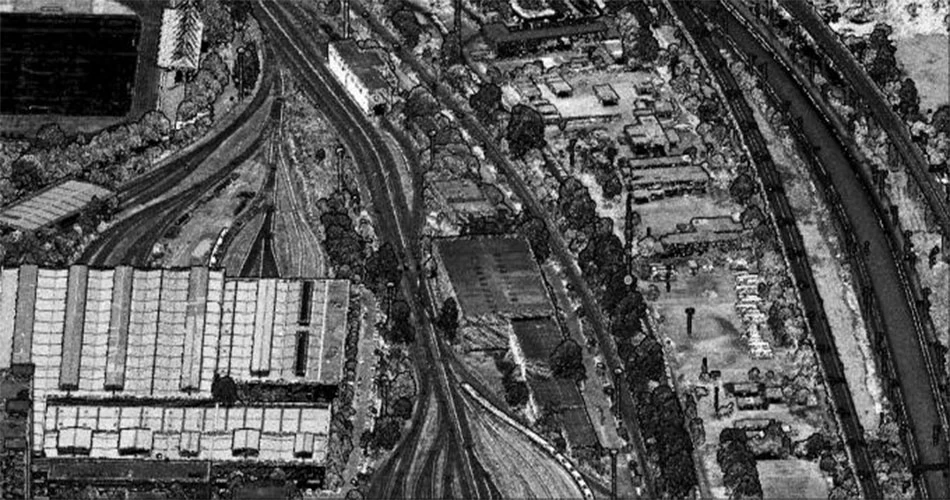
Application for Terrain Survey
Please feel free to contact us if you are interested in this product.

