


- Browse Categories
- YQFH Drone
- DJI Drone
- Other Drone
- Drone Payloads
- Robot
- Pipeline Detection Instrument
- 3D Laser Scanner
- Industrial Measurement Devices
- Weather Station Series
- Optical Survey Instruments
- GNSS RTK & CORS System
- BDS System Products
- Visual Displacement Monitoring System
- UWB Indoor Positioning System
- Hydrology Products
- Others
- Spectrometer
- Wet Blast Machine
- SDI Soil Tester
- Pengjin Smart Flying Drone Patrol and Inspection System
- Supercomputing
- Module
- Viscometer
- Electric Hygro-thermograph
- Echo Sounder
- Processing Software
- Keson Measuring Tools
UAV Lidar
-
-
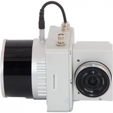
32 Channel UAV LiDAR Scanner HESAI XT Laser Sensor 3D Scanning
gAirHawk UAV LiDAR Scanner is a kind of short-range, compact LiDAR point cloud data acquisition system, integrated HESAI XT laser scanner, GNSS and IMU positioning and attitude determination system, and storage control unit, is able to real-time, dynamically, massively collect high-precision point cloud data and rich image information. It is widely used in the acquisition of 3D spatial information in surveying, electricity, forestry, agriculture, land planning.
More
-
-
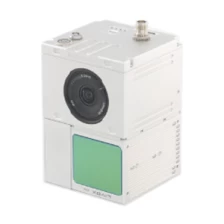
UAV LiDAR Scanning System LD-100C+
LD-100C+ liDAR scanning system is a UAV measurement system independently developed by Geosun company. It highly integrates laser scanner, GNSS satellite positioning system, IN S inertial navigation system and camera, and can quickly obtain high-precision laser point cloud number. It can be widely used in Digital city construction, Industry, Land survey, Forestry and AgricultureMore
