


- Browse Categories
- YQFH Drone
- DJI Drone
- Other Drone
- Drone Payloads
- Robot
- Pipeline Detection Instrument
- 3D Laser Scanner
- Industrial Measurement Devices
- Weather Station Series
- Optical Survey Instruments
- GNSS RTK & CORS System
- BDS System Products
- Visual Displacement Monitoring System
- UWB Indoor Positioning System
- Hydrology Products
- Others
- Spectrometer
- Wet Blast Machine
- SDI Soil Tester
- Pengjin Smart Flying Drone Patrol and Inspection System
- Supercomputing
- Module
- Viscometer
- Electric Hygro-thermograph
- Echo Sounder
- Processing Software
- Keson Measuring Tools
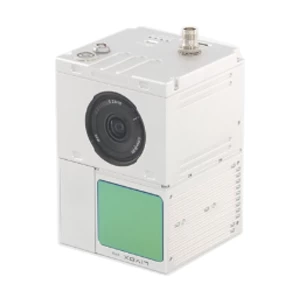
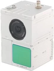
UAV LiDAR Scanning System LD-100C+
- Brand Name:PJK
- Model Name:LD-100C+
- Place of Origin:China
- Warranty:1 year
- Support Express:Sea freight, air freight
LD-100C+
UAV LiDAR Scanning System LD-100C+
Color Point Cloud with Highly Integrated LiDAR Camera

LD-100C+ liDAR scanning system is a UAV measurement system independently developed by Geosun company. It highly integrates laser scanner, GNSS satellite positioning system, IN S inertial navigation system and camera, and can quickly obtain high-precision laser point cloud number. It can be widely used in Digital city construction, Industry, Land survey, Forestry and Agriculture
| System Parameter |
| Accuracy ≤10cm@110m | Dimension 15.5*9.2*9.3cm | |
| Weight 1036g | Storage 64 GB Maxsupport 128GB TF card | |
| Working Temperature -20°~+55° | Carrying Platform Multi Rotor/VTOL |
|
Laser Unit
|
|
Measuring Range 190m@10%
|
FOV 70°the cirular view
|
|
|
Laser Class 905nm Class1 (IEC 60825-1:2014)
|
Range Accuracy (1σ @ 20m) 2 cm
|
|
|
Laser Line Number Equivalent to 64-beam
|
Data Triple echo,720,000 Points/Sec
|
|
POS Unit
|
|
Update Frequency 200HZ
|
Position Accuracy ≤0.05m
|
|
|
Pitch /Roll Accuracy 0.015°
|
GNSS SignalType GPS L1/L2/L5,GLONASS L1/L2
BDS B1/B2/B3,GAL E1/E5a/E5b
|
|
|
Heading Accuracy 0.040°
|
|
Pre-Processing Software
|
|
POS(Trajectory) Software Shuttle
|
PointCoudSoftware gAirHawk
|
 |
|||||
|
Camera
|
|||||
|
|||||
|
Operation Efficiency Table
|
|
Flight Height (m) Accuracy Single Flight Operation(km²)
|
| 50 ≤5cm 0.08 |
|
70 ≤7cm 1.28
|
|
100 ≤10cm 1.92
|
|
Mission Planning Software (optional)
|
|
Mission Planning Software Customized Rute Planning Software — WayPoint Master
|
|
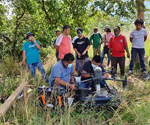
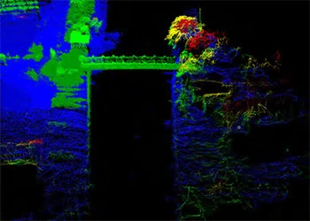
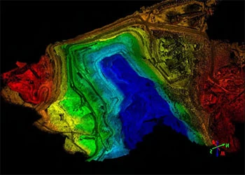
Application Case
|
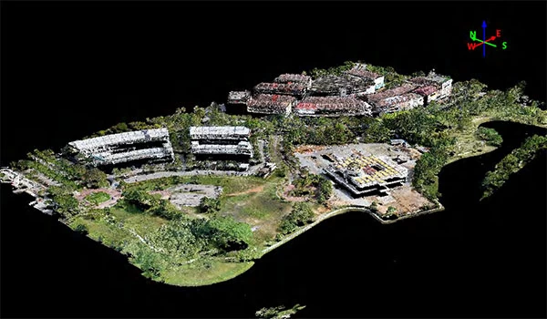 |
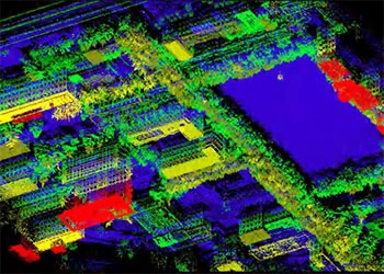
Model:LD-100C+
Flightspeed: 10m / s
Flight altitude: 80m
Application: Urban Construction
Project location:Malaysia
|
|||
 |
||||
 |
 |
 |
||
Tag:
UAV Lidar

