


- Browse Categories
- YQFH Drone
- DJI Drone
- Other Drone
- Drone Payloads
- Robot
- Pipeline Detection Instrument
- 3D Laser Scanner
- Industrial Measurement Devices
- Weather Station Series
- Optical Survey Instruments
- GNSS RTK & CORS System
- BDS System Products
- Visual Displacement Monitoring System
- UWB Indoor Positioning System
- Hydrology Products
- Others
- Spectrometer
- Wet Blast Machine
- SDI Soil Tester
- Pengjin Smart Flying Drone Patrol and Inspection System
- Supercomputing
- Module
- Viscometer
- Electric Hygro-thermograph
- Echo Sounder
- Processing Software
- Keson Measuring Tools
UAV LiDAR Scanning System LD-130X
- Brand Name:PJK
- Model Name:LD-130X
- Place of Origin:China
- Warranty:1 year
- Support Express:Sea freight, air freight
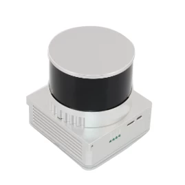
32 Channel UAV LiDAR Scanner HESAI XT Laser Sensor 3D Scanning
gAirHawk UAV LiDAR Scanner is a kind of short-range, compact LiDAR point cloud data acquisition system, integrated HESAI XT laser scanner, GNSS and IMU positioning and attitude determination system, and storage control unit, is able to real-time, dynamically, massively collect high-precision point cloud data and rich image information. It is widely used in the acquisition of 3D spatial information in surveying, electricity, forestry, agriculture, land planning.
Minimum Order Quantity : 1
Price : Negotiation
Packaging Details : Suit Case 530*430*240 mm
Delivery Time : 10-15 work days
Payment Terms : T/T, Western Union
Supply Ability : 30 SETS/Month
Place of Origin: China
Brand Name: PJK
Certification: CE, ISO
Model Number: LD-130X LiDAR Scanning System
Pandar XT
High precision. Minimum range of zero.
Proprietary LiDAR ASICs.
32-Channel Short-Range Mechanical LiDAR
Specification
|
|||||||||||||||||||||||||||||||||||||||||||||||||||||||||||||||||||
Application for Terrain Survey
Package
It is packed by suit case with EVA material liner inside, then covered by hard carton box. It is suitable for air shipment and sea shipment.
Please feel free to contact us if you are interested in this product.

- Other Products


