


- Browse Categories
- YQFH Drone
- DJI Drone
- Other Drone
- Drone Payloads
- Robot
- Pipeline Detection Instrument
- 3D Laser Scanner
- Industrial Measurement Devices
- Weather Station Series
- Optical Survey Instruments
- GNSS RTK & CORS System
- BDS System Products
- Visual Displacement Monitoring System
- UWB Indoor Positioning System
- Hydrology Products
- Others
- Spectrometer
- Wet Blast Machine
- SDI Soil Tester
- Pengjin Smart Flying Drone Patrol and Inspection System
- Supercomputing
- Module
- Viscometer
- Electric Hygro-thermograph
- Echo Sounder
- Processing Software
- Keson Measuring Tools
The D390 is a cost-effective and rugged bathymetric solution that uses an advanced 200 kHz transducer to match different hydrographic conditions and significantly improve sounding performance and usability. The 7-degree beam angle provides focused directional and lateral resolution. In addition, the water depth recording frequency can be as high as 60 Hz. Using pulse width discrimination and automatic redundant data suppression enhance data accuracy and reliability.
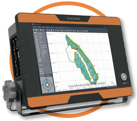
Easy to operate with its feature-rich CHCNAV HydroSurvey software, the D390 clearly displays real-time depth readings and the survey project parameters on its 12-inch HD touch screen. The standard serial interfaces for motion sensors and GNSS differential receivers allow centimeter position precision.

Turnkey hydrographic solution
Cut down mission mobilization cost by 20%
The D390 is a fully integrated and affordable single frequency echo sounder solution combined with the performance of an industrial PC. Light, portable and with a rugged IP66 aluminum alloy enclosure, the D390 is easy to set up and to deploy in any remote location. Its 12-inch touch screen display dramatically eases field survey operation making data always visible at a glance. The D390 extended sounding capability (200 kHz and up to 500 W) output provides demanding professionals with the perfect solution to perform bathymetric survey in inland waterways, rivers, reservoir and coastal areas.
Standard DGNSS and sensors interfaces
Full compatibility with NMEA data
The D390 is easy to pair with any GNSS RTK receiver outputting standard NMEA messages and offers enhanced compatibility with CHCNAV GNSS receivers. Your bathymetric surveys in shallow and medium depth water are achieved with high precision in real-time.
Simplified survey operation
Fast learning curve
HydroSurvey7 manages your project within a single intuitive software from positioning and navigation to data acquisition and data processing and export in CSV format. Further data processing such as volume computation, contour lines are easily achieved with 3rd party bathymetric software to suit all your operational needs.
Ultra-fast startup without lag time
Achieve maximum productivity and save survey time
The embedded Windows 10 operating system provides fast boot and total operation stability. The D390 allows you to start your survey rapidly, save time and enable you to achieve results faster. Survey data are secured on internal storage and always available to transfer on a USB flash disk for extreme convenience.
SPECIFICATIONS
| Measurement Parameters | |
| Frequency | 200 kHz |
| Output Power | 500 W RMS max |
| Depth Range | 0.15 m to 300 m |
| Accuracy | ± 0.01 m + 0.1% of depth |
| Resolution | 0.01 m |
| Sampling Rate | Up to 60 Hz |
| Draft Adjustment | 0 m to 9.9 m |
| Sound Velocity Adjustment | 1300 m/s to 1700 m/s |
| Data Output |
- User defined - CHCNAV - NMEA SDDPT/SDDBT - Original Waveform |
| Display | 12-inch resistive touch screen |
| LCD Resolution | HD 1024 × 768 pixels |
| Interface |
- 2x RS -232 serial ports - 2x USB 3.0 ports - 2x USB 2.0 ports |
| RAM | 4 GB DDR3L 1600 MHz |
| ROM | 32 GB |
| CPU | 1.6 GHz |
| Power Consumption | 25 W |
| Physical | |
| Size (L x W x H) | 36.5 cm × 25.8 cm × 0.95 cm |
| Weight | 4.7 kg |
| Pulse Power | 300 W |
| Input Power | 10 V DC to 30 V DC |
| Operating Temperature | -30°C to + 60°C (-22°F to +140°F) |
| Ingress Protection | IP66 |
Tel:+8613828792860
Wechat:PJK13828792860
Contact Person:Janet luo

- Other Products


