


- Browse Categories
- YQFH Drone
- DJI Drone
- Other Drone
- Drone Payloads
- Robot
- Pipeline Detection Instrument
- 3D Laser Scanner
- Industrial Measurement Devices
- Weather Station Series
- Optical Survey Instruments
- GNSS RTK & CORS System
- BDS System Products
- Visual Displacement Monitoring System
- UWB Indoor Positioning System
- Hydrology Products
- Others
- Spectrometer
- Wet Blast Machine
- SDI Soil Tester
- Pengjin Smart Flying Drone Patrol and Inspection System
- Supercomputing
- Module
- Viscometer
- Electric Hygro-thermograph
- Echo Sounder
- Processing Software
- Keson Measuring Tools
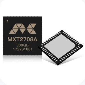
GNSS baseband and RF integrated SoC MXT2708A
The MXT2708A is a high-performance baseband and RF integrated SoC, Designedand developed by MXGNSS using a 40nm process based on completely indepen-dent intellectual property rights. Utilizing the broadband radio frequency technolo-gy independently developed by MXGNSS, the chip supports all deployed satelliteconstellations, including BDS, GPS, GLONASS, Galileo, QzSS, etc.lt initiativelyachieves the target that a single chip synchronously receives satellite signals fromBDS/GPS/GLONASS Galileo systems, effectively improving the positioning perfor-mance, including sensitivity, the initial positioning time, positioning accuracy, etcWith its high integration and multi-function features, MXT2708A is suitable forautomotive, industrial, consumer electronics, and other fields.

Technical Feature
 |
 |
 |
 |
|||
| 40nm Process baseband and RF integration | Support BDS/GPS/GLONASS/Galileo | High sensitivity design | Support AGNSS and DGNSS | |||
 |
 |
 |
||||
| Smart Supress anit-jamming technology | Supporting precision timing(optional) | Supporting RTK algorithm(optional) |
Specifications
| Signal Tracking | GPS/QZSS L1CA / L2C /L5 |
| BDS B1I/ B1CB2I / B2a | |
| GLONASS L1 / L2 | |
| Galileo E1 / E5a | |
| Position Accuracy | 2.0m CEP |
| RTD:0.5m CEP | |
| RTK: 2.0cm+1ppm CEP | |
| TTFF | Cold Starts :30s |
| Hot Starts: 1s | |
| Sensitivity | Acquisition : -147dBm |
| Tracking : -164dBm | |
| Velocity Accuracy | 0.05m/s |
| Nav. Update Rate | 1 / 2 / 5 / 10HZ |
| 1PPS Accuracy | 20ns |
| Operational Limits | Altitude : 18000m |
| Velocity : 515m/s | |
| Dynamics : 4g | |
| Nav. Data Format | NMEA 0183 |
| MXT Data Format | |
| RTCM 2.3 / 2.4 / 3.X | |
| Power Consumption | 35mA@3.3V |
| Package | 5x5mm QFN |
| Supply | 3.3V |
| Temperature | Ambient -40℃~85℃ |
| Store -40℃~85℃ |
Application Area
 |
 |
 |
 |
|||
| Electric Timing | Deformation Monitoring | Base Station Orientation | Itelligen Robot | |||
 |
 |
 |
 |
|||
| Shipborne Navigation | Smart Agriculture | Vehicle Road Collaboration | Navigation and Positioning |

- Other Products


