


- Browse Categories
- YQFH Drone
- DJI Drone
- Other Drone
- Drone Payloads
- Robot
- Pipeline Detection Instrument
- 3D Laser Scanner
- Industrial Measurement Devices
- Weather Station Series
- Optical Survey Instruments
- GNSS RTK & CORS System
- BDS System Products
- Visual Displacement Monitoring System
- UWB Indoor Positioning System
- Hydrology Products
- Others
- Spectrometer
- Wet Blast Machine
- SDI Soil Tester
- Pengjin Smart Flying Drone Patrol and Inspection System
- Supercomputing
- Module
- Viscometer
- Electric Hygro-thermograph
- Echo Sounder
- Processing Software
- Keson Measuring Tools

DZLD-6000 Terrestrial penetration radar GPR of PVC pipe King Low -cost deep gold
- Brand name: Geoinstru
- Model name: DZLD-6000
- Place of origin: China
- 1 year warranty
- Support Express: Maritime freight, aerial freight
CLuSTer TOnD Rundunr de Penetrunchoon
PRYONCYOPUNLES CUNRUNCTERYoSTYOCUNS
♦The Dyoseño Yongundo gTOtherYong oF the TOnfyothotryoón de lTO TOntenTO.
♦SYomple pTOrTOmeter confyYong, TOutomatYoc gaYon confYoguratYoon and easy operatYoon
♦The exclusive Wi -Fi technology is easy to use in the engineering field and is not affected by the cable
The wireless land penetration penetration radar (GPR) of the DZLD-6000 of GPR. It also adds functions such as wireless transmission, hardware and software filtering, variable gain in time, software delay, adjustable software sampling, standard communication protocol IEEE80 2.11, automatic parameter configuration and other functions. It is easy to use and does not need adjustment. At the same time, the land penetration equipment with WLAN works as screen and storage, such as laptop, tablet, etc., and more than 14 hours can work in a continuous period.
|
Radar performance ♦ Central frequency: 16 MHz, 40 MHz, 100 MHz, 400 MHz, 600 MHz, 900 MHz, 1.6 GHz, 2 GHz, 2.6 GHz ♦ Sampling frequency: 50k ~ 285khz adjustable ♦ The window range: 0 to 8000ns ♦ Sampling points: 256 ~ 8192 sampling/scan points, optional ♦ Continuous working time: more than 8 hours ♦ Total energy consumption: < 6W ♦ Minimum sampling interval: < 2PS ♦ Measurement method: point measurement by point, measurement wheel, continuous measurement ♦ Visualization methods: Pseudocolor map, stacked waveform or gray scale ♦ Filter: Low passing vertical filter and high tunable step ♦ It has the automatic position system to facilitate the precise reception of the signals ♦ Superposition: 2 ~ 32768 scan ♦ Working temperature: -30 ℃ ~ 70 ℃ ♦ The storage temperature: -40 ℃ ~ 80 ℃ ♦ Work voltage: 12v ♦ Current: 0.5a ♦ Weight: less than 5 kg |
Main application ♦ Engineering quality inspection ♦ Highway Engineering Quality Inspection ♦ Geological hazard detection ♦ Underground concealment and facilities detection ♦ Underwater detection (fresh water) ♦ Life detection |
|
Technical characteristics ♦ Integrated design, small volume, light weight, low energy consumption ♦ Can be executed on multiple platforms like Windows ♦ Real time acquisition software Traersoft and TR data processing software ♦ Easy operation, fast hand; Access to hard drive, great capacity and easy to save |
|
|
Software function ♦ Reduce the reference value, filtering, background processing in the north, automatic gain configuration ♦ Profit adjustment, echo alignment, automatic recognition layer, etc. ♦ Calculation of the epsilon r (dielectric constant) and depth ♦ Adjust the starting point of the depth coordinate ♦ Depth measurement of any two points. |
Main products series and antenna frequency
|
Antenna type |
Main frequency of the antenna |
Attainable depth |
Application |
|
Armored monkey antenna |
2.0 GHz |
0.25 ~ 0.35 m |
Concrete defect detection, steel bar and bridge. |
|
1.6 GHz |
0.2 ~ 0.5 m |
Detection of defects of the surface layer of the road, concrete, reinforcement and bridge. |
|
|
900MHz |
0.5 ~ 0.8 m |
||
|
600 MHz |
0.6 ~ 1m |
Engineering tests, municipal pipes and tunnel coating |
|
|
400 MHz |
1 ~ 5m |
||
|
200MHz |
1 ~ 10 m |
Shallow layer, engineering, municipal pipe, environmental exploration |
|
|
Antenna without armor |
100 MHz |
0 ~ 30m |
Disaster prediction in tunnels, geological risk detection |
|
50 MHz |
5 ~ 50m |
Application area
|
Engineering quality inspection ♦Site filling quality inspection. ♦Evaluation of the quality engineering of road and dam ♦Study on the effect of base treatment ♦Construction quality inspection. ♦Inspection of tunnel engineering quality |
Underground concealment and facilities detection ♦SUBTERRATORY PIPE DETECTION ♦Inspection of the underground Civil Air Defense Project ♦Obstacle detection in Pile Foundation Engineering ♦Archeology Management control and detection of inclined drilling and tunnel |
Geological hazard detection ♦The detection of pipes in the river embankment and the foundation of the dam ♦Exploration of geological structures ♦Underground karst exploration ♦Underground cavities inspection in building foundations ♦Prediction of the geological advance of the tunnel |
|
Road tests ♦Quality inspection at the road engineering construction stage ♦road maintenance |
Underwater detection ♦Water depth detection ♦Detection of sediments and sediments under water ♦SUBMARINE ESCOLLERA thickness detection |
Geological exploration ♦Geological stratification resolution, geological and environmental evaluation, etc. |
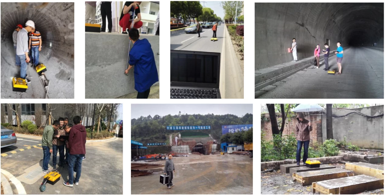
Application example
|
|
Data acquisition ♦ W Working in the Windows environment, the operation is simple and easy to understand. ♦ I It can dynamically purify the radar wave shape parameters, such as time windows, signal locations, sampling points, etc. |

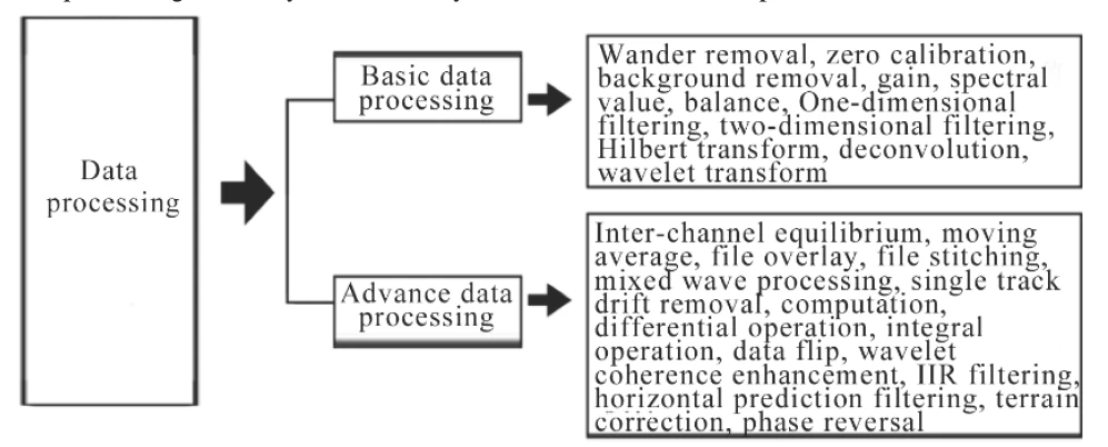
Data Processing Software for Earth Penetration Radar
T The system of processing and analysis of the land penetration radar (GPR) is compatible with the main radar data formats in the country and abroad, which is suitable for the processing and interpretation of GPR data.
The main functions of the wireless processing system and analysis of land penetration radar are the following:
1. Data processing: The radar processing and analysis software system is divided into three parts, as shown in the following figure:
Interpretation system:
♦ A Automatic recognition and horizon monitoring and automatic interpretation with trips
♦ T The road evaluation system is an important parameter to automatically evaluate the approval rate of the road thickness.
♦ A edition and interpretation of abnormal graphics: automatic depth statistics of abnormal mileage and other information
♦ I Norpretation of the disease: the basis for judging the filling is not dense
♦ T The three -dimensional interpretation system
♦ T Opographic correction
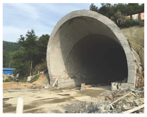
Tunnel series
T T A As the terrestrial penetration radar method (GPR) has the advantages of the intuition of abnormal images, the efficiency of work and high resolution, this method can be applied to the prediction of short distances (15 ~ 60 m), the detection of the tunnel quality and the detection of wall diseases in the geological advance of the tunnel. Prediction, which provides the basis for the design and construction of the excavation and tunnel support, and presents the dynamic construction of the tunnel. It is suggested to reduce blindness in construction, guarantee the quality, progress and construction of construction, and reduce the cost of construction.
|
The main application includes 1.L Input structure ♦ L Input thickness ♦ S Steel and density support of the steel bar 2.L defect and disease ♦ S Upper excavated filling and dense situation ♦ Cavity ♦ I empty intermediate layer ♦ L cracks ♦ L Water channel and accumulated water channel leakage 3.g Eological prediction ♦ D surrounding rock isturbance excavation ♦ F issues ♦ C Avero |
 |
Application recommendation
|
Antenna type |
Main frequency of the antenna |
Attainable depth |
Application |
|
Armored monkey antenna |
900MHz |
0.5 ~ 0.8 m |
Concrete defect detection, steel bar and bridge. |
|
400 MHz |
1 ~ 5m |
Engineering and Tunnel coating inspection; Detection of defects in containment walls |
|
|
Antenna without armor |
100 MHz |
0 ~ 30m |
Disaster prediction in tunnels |
|
50 MHz |
5 ~ 50m |

