


- Browse Categories
- YQFH Drone
- DJI Drone
- Other Drone
- Drone Payloads
- Robot
- Pipeline Detection Instrument
- 3D Laser Scanner
- Industrial Measurement Devices
- Weather Station Series
- Optical Survey Instruments
- GNSS RTK & CORS System
- BDS System Products
- Visual Displacement Monitoring System
- UWB Indoor Positioning System
- Hydrology Products
- Others
- Spectrometer
- Wet Blast Machine
- SDI Soil Tester
- Pengjin Smart Flying Drone Patrol and Inspection System
- Supercomputing
- Module
- Viscometer
- Electric Hygro-thermograph
- Echo Sounder
- Processing Software
- Keson Measuring Tools
Category
-

-
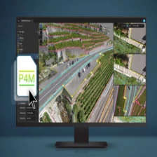
Advanced agriculture mapping software for aerial crop analysis and digital farming Pix4dfield
Advanced agriculture mapping software for aerial crop analysis and digital farming Pix4dfield
More
-
-
Fully automated processing software PIX4Dmatic
PIX4Dmatic:Next generation photogrammetry software for professional drone and terrestrial mapping
More
-
-
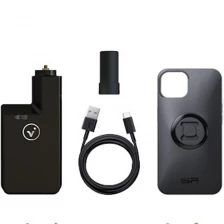
Portable 3D Scanner PIX4D ViDoc RTK Rover Special for Smartphones and Tablets
The viDoc RTK rover for PIX4Dcatch is specially designed to accurately capture 3D space from the ground on certain iOS devices equipped with LiDAR sensors, but it also works with certain other models, including Android devices.
Please click " moreFor more information, see below.
More
-
-
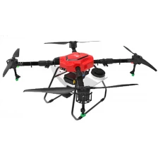
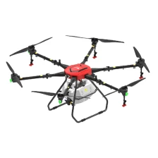
YFX-14 Multi-rotor Spraying Drones
Original V-shaped medicine box, planting fertilizer bait medicine integrated machine
More
-
-
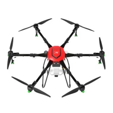
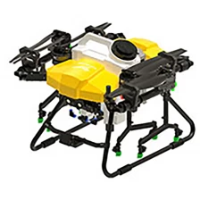
YFX-25 Multi-rotor spraying drone
Strong wind field, large capacity, all-around machine
More
-
-
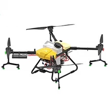
YFX-32 Multi-rotor spraying drone
Multi-functional sowing and drug application in one
More
-
-
YFS-16 Multi-rotor electric / oil-electric hybrid spraying drone
Planting fertilizer bait machine
More
-
-
YFS-22 Multi-rotor electric / oil-electric hybrid plant protection UAV
Planting fertilizer bait machine
More
-
-
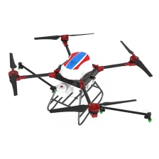
YFM-D10L Multi-rotor Spraying Drones
Skin solid fall resistance, economic and practical Spraying Drones
More
-
-
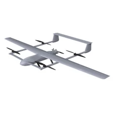
TY-900 Heavy duty patrol UAV
Heavy oil engine / composite wing / vertical landing
Fast flight time / speed / distance / strong adaptability
More
-
-
YFM-M12L Multi-rotor plant protection UAV
The perfect combination of industrial design and plant protection application
More
-
-
YFM-M16L Multi-rotor plant protection UAV
"Big" show skill, larger load and more efficient plant protection machine
More
