







- Browse Categories
- YQFH Drone
- DJI Drone
- Other Drone
- Drone Payloads
- Robot
- Pipeline Detection Instrument
- 3D Laser Scanner
- Industrial Measurement Devices
- Weather Station Series
- Optical Survey Instruments
- GNSS RTK & CORS System
- BDS System Products
- Visual Displacement Monitoring System
- UWB Indoor Positioning System
- Hydrology Products
- Others
- Spectrometer
- Wet Blast Machine
- SDI Soil Tester
- Pengjin Smart Flying Drone Patrol and Inspection System
- Supercomputing
- Module
- Viscometer
- Electric Hygro-thermograph
- Echo Sounder
- Processing Software
- Keson Measuring Tools
-

-
Professional high-precision engineering total station SOKKIA IM100 series
The IM-100 (Intelligent Measurement Total Station) incorporates all the necessary features at a cost-effective price. Meet the needs of the most demanding research layouts and completed projects.
More
-
-
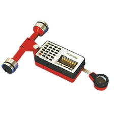
Original best price KP-90N digital koizumi planimeter MAP types digital planimeter
The most standard model of "PLACOM" N-Series has made the excitingly highest attainment in the history of Planimeter ever made. Measuring capacity is remarkably enlarged. Measuring by 6-digit pulse count enables to measure 100 times larger accumulative area than ordinary planimeters. Easy calculations of Cumulative and Average Value Measurement. Conversion of Unit and Scale value is made by easy operation. "WONDER", it is a most worthy word to be given to this "PLACOM" N-Series.
More
-
-
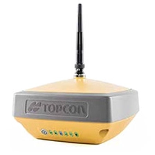
topcon rtk gps hyper vr gnss receiver
Hyper VR: High-tech and versatile GNSS receiver
With its compact and robust design, the HiPer VR is packed with cutting-edge GNSS technology.
More
-
-
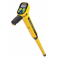
GA-92XTd Radiodection Schonstedt Magnetic Metal Locator
Fully automated SuperSting™ has been thoroughly field-tested in every extreme environment on the planet and is used in over 700 peer-reviewed journal articles, with the highest accuracy and lowest noise levels in the industry It will achieve this. The SuperSting™ series of electrical resistivity tomography equipment is the industry's first multi-channel feature and is being continuously improved and updated with additional features.
More
-

-
Radiodetection SPX RD8200 most advanced precision locators. ground locator driven best on-site practise pipeline detector
RD8200 Locator Specification
Product Descriptions
Multi-purpose Precision Locator
Cable and Pipe Locator
Locate System Receiver
Multi-function Precision Locator
More
-
-
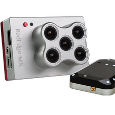
MicaSense Sensor RedEdge-MX Multispectral Camera For UAV Mapping Drone
The RedEdge-MX is a rugged, professionalmultispectral sensor designed for field-scaleprecision agriculture and environmentalmonitoring.
The modular payload captures ffve spectral bands in a single ffight, delivering reliable data for analysis and actionable insights.
A rugged, built-to-last, professional multispectral sensor for agriculturaldrone mapping. Captures five spectral bands, and is one of the mostflexible solutions on the market.More
-

-
Professional Survey Faro Laser Scanner Focus S350
MoreThe FocusS 350 combines all benefits from FARO’s well-known Focus3D Laser Scanners with today’s most innovative features to perform laser scanning in both indoor and outdoor environments - truly mobile, fast and reliable. The FARO FocusS 350 provides the next level of laser scanning for all applications in industries like Construction, BIM/CIM, Public Safety and Forensics. cs.
-
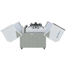
-
Drone Airport (Customization Available)
Dimensions: 1.3m × 1.1m × 1.2m (Closed); 2.8m × 1.1m × 1.2m (Expanded)
More
Weight: V4.0 Charging Version approx. 220 kg; Battery-Swapping Version approx. 260 kg.
Maximum Inspection Range: NCC/FCC: 15 km; CE/MIC: 8 km; SRRC: 8 km
Operating Ambient Temperature: -20°C to 50°C
Temperature Control Method: Industrial Air Conditioning
Maximum Storage Capacity: 8 batteries (Battery Swapping Version)
Emergency Operation Time: 300 minutes
Video Transmission Latency: 0.3 seconds
Service Ceiling: 4,000 m
Standby Power: 100W
Maximum Power: 2100W
Protection Rating: IP55 (Customizable)
-

-
Low-cost surveying machine CHC I90 PROGNSS GPS RTK
The i90 Pro GNSS receiver combines the latest CHCNAV IMU-RTK technology with compatibility with L-band correction services to extend RTK positioning anywhere. It integrates cutting-edge GNSS RTK engine with calibration capabilities. Free high-end IMU sensors and
More
Advanced GNSS tracking features greatly increase the availability and reliability of the RTK.
-
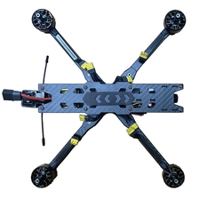
-
First Person View Drones YFM7-A (Customization Available)
Features:
1.New Frame design ensures reliable strength and makes flight more stable
2.Efficient 2810 motor, takeoff load weight of about 1.5kg,Max 2KG
3. The first visual flight experience, precision flight
4. Nose rectification design to increase flight efficiency
5. Larger battery compartment, convenient to put larger batteries
6. Maximum flight altitude of 5000 meters
7. Maximum flight speed 140 km/h
8. Maximum payload flight time about 7 minutes
9. No-load flight time about 20 minute
More
-
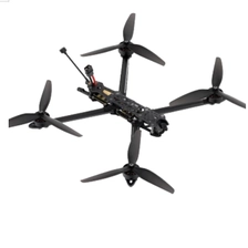
-
First Person View Drones (Customization Available)
Frame: LY10-A
More
Wheelbase: 435mm
Flight Controller: F405 FC
Video Transmission: RAD 2.5W
Motor: EM3115 900KV
Propellers: HQ1050
Operating Temperature: -10°C - 40°C
Receiver: Elrs915
Antenna: MOMODA 5.8GHz Antenna
GPS: M10
Camera: Caddx Ratel 2 (Removable Lens)
Recommended Battery: Lipo 6S 5600mAh with XT90 Plug
-
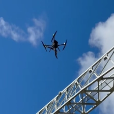
-
Inspection Drones+Robotic Arm (Customization Available)
Features:
High operational efficiency and time-saving and labor-saving: The inspection drone + robotic arm system enables continuous and efficient de-icing, significantly surpassing manual de-icing efforts, which are limited by physical strength and harsh environments.
Significantly improved safety: Remote control operation is achieved, eliminating the need for personnel to climb towers, fundamentally eliminating the dual risks of working at height and in freezing temperatures.
Strong ability to handle complex terrain: The inspection drone + robotic arm system is suitable for operations in narrow and rugged terrain that is inaccessible to large vehicles.
More
