


- Browse Categories
- YQFH Drone
- DJI Drone
- Other Drone
- Drone Payloads
- Robot
- Pipeline Detection Instrument
- 3D Laser Scanner
- Industrial Measurement Devices
- Weather Station Series
- Optical Survey Instruments
- GNSS RTK & CORS System
- BDS System Products
- Visual Displacement Monitoring System
- UWB Indoor Positioning System
- Hydrology Products
- Others
- Spectrometer
- Wet Blast Machine
- SDI Soil Tester
- Pengjin Smart Flying Drone Patrol and Inspection System
- Supercomputing
- Module
- Viscometer
- Electric Hygro-thermograph
- Echo Sounder
- Processing Software
- Keson Measuring Tools
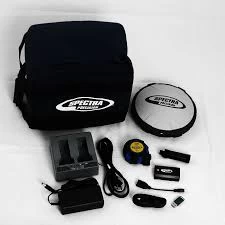
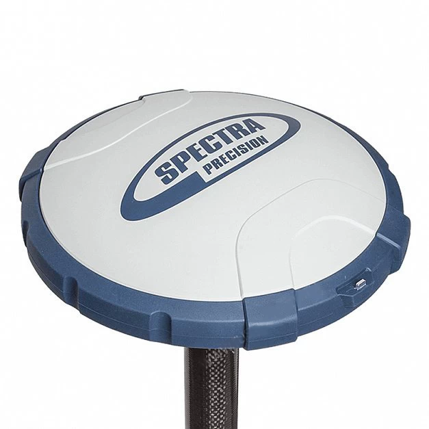
Spectra Precision SP60 Advanced Design GNSS Receiver
- Origin: USA
- Brand name: Spectra Precision
- Constellations: GPS, GLONASS, Hokuto, Gelileo, SBAS
- Horizontal DGPS Accuracy: 25 cm 1 ppm
- Vertical DGPS Accuracy: 50 cm 1 ppm
- Horizontal RTK Accuracy: 8 mm 1 ppm
- Vertical RTK Accuracy: 15 mm 1 ppm
- RTK initialization range: 40km or more
- GNSS Channel: 240
- I/O interface: RS232, USB, Bluetooth
- Internal memory: 256MB
- Battery life: 10 hours
Spectra Precision SP60 Advanced Design Trim R10 RTK Gnss Receiver

Product Description
The Spectra Precision SP60 meets all surveying needs, from simple post-processing to sophisticated RTK and CenterPoint RTX-enabled spacecraft solutions via standard UHF or proprietary long-range Bluetooth-based and spacecraft systemsになったんです。 English: The first thing you can do is to find the best one to do. A new generation GNSS receiver that offers a high level of flexibility.
Combining unique full signal tracking and processing Z-Blade GNSSentric technology with L-band functionality for satellite distribution CenterPoint® RTX services, the SP60 receiver allows for the most reliable measurement and performance anywhere in the world under any conditions It provides the highest possible accuracy.

1. Main features
* Enhanced survey scalability
*New 240 Channel 6G ASIC
* Z-Blade GNSS center
* CenterPoint RTX compatible rover
* Built-in TRx UHF wireless
*Long distance Bluetooth
* Anti-theft protection

2. Specifications
| General | |
| Weight | 2.08 lbs (0.94kg) |
| size | 8.3 inches long x 8.3 inches wide x 2.3 inches high (21.1 x 21.1 x 5.8 cm) |
| battery | Lithium-ion battery, DC power supply, up to 10 hours |
| Display/Keypad | |
| type | LED light |
| Touch screen | Not applicable |
| software | |
| on board | Spectra Precision Survey Office Basic Software |
| 240 GNSS Channels | |
| GPS | L1C/A, L1P(Y), L2P(Y), L2C |
| Gronus | L1C/A, L2C/A, L3 |
| Hokuto | B1 (Phase 2), B2 |
| Galileo | E1, E5b |
| Quasi-Zenith Satellite | L1C/A, L2C, L1SAIF |
| SBAS | L1C/A |
| L band | yes |
| Real-time Accuracy (RMS) | |
| SBAS (WAAS/Egnos/MSAS/Gaggan) |
Horizontal: <50cm Height: <85cm |
| Real-time DGPS location | Horizontal: 25cm1ppm
Vertical: 50cm1ppm |
| Real-Time Kinematic Position (RTK) | Horizontal: 8cm1ppm
Height: 15cm 1ppm |
| Post-processing accuracy (RMS) | |
| Static and fast static | Horizontal: 3mm0.5ppm
Vertical: 5mm0.5ppm |
| High precision static | Horizontal: 3mm0.1ppm
Height: 3.5mm 0.4ppm |
3. Packing and shipping

If you are interested in this product, please feel free to contact us.

