


- Browse Categories
- YQFH Drone
- DJI Drone
- Other Drone
- Drone Payloads
- Robot
- Pipeline Detection Instrument
- 3D Laser Scanner
- Industrial Measurement Devices
- Weather Station Series
- Optical Survey Instruments
- GNSS RTK & CORS System
- BDS System Products
- Visual Displacement Monitoring System
- UWB Indoor Positioning System
- Hydrology Products
- Others
- Spectrometer
- Wet Blast Machine
- SDI Soil Tester
- Pengjin Smart Flying Drone Patrol and Inspection System
- Supercomputing
- Module
- Viscometer
- Electric Hygro-thermograph
- Echo Sounder
- Processing Software
- Keson Measuring Tools
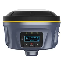


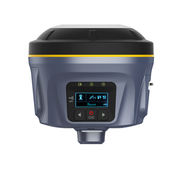
professional low power small size survey instrument China brand M86U gnss rtk gps receiver
- Brand Name:PJK
- Model Name:M86U
- Place of Origin:China
- Warranty:1 year
- Support Express:Sea freight, air freight
Product Description
Advanced test instrument PJK brand M86U GNSS RTK receiver base and recover
|
|
|
|
|
|
|
|
|
|
|
|
|
|
|
|
|
|
|
|
|
|
|
|
|
|
|
|
|
|
|
|
|
|
|
|
|
|
|
|
|
|
Key Features:
| 1.OLED display
2.Full constellation
3.Ultra long range radio
4.Internal GSM antenna
|
5.Radio/CORS repeater
6.Large capacity battery
7.Magnesium alloy housing atented
8.Physical offset technology
|

COMMUNICATIONS & DATA STORAGE/O Interface♦1 LEMO port (5pin): Supports power input, serial port control, and external radio communication♦1 micro USB port: Data download, OTG♦1 sim card slot: Supports micro sim card♦1 antenna port: UHF antenna interfaceRadio modem
♦ Transmit power: 1w/2w/5w switchable, the work range is greater than 6km
♦ Frequency band: 410MHz-470MHz; supports to freely set the frequency
♦ Supports to retransmit correction from CORS; Compatible with other brands
Cellular
♦ Integrated full frequency band 4G modem, supports WCDMA/CDMA2000/TDD-LTE /FDD-LTE
WiFi
♦ 802.11 b/g standard, access point and client mode, supports to access to hotspot to transfer corrections
Bluetooth♦ Fully integrated Bluetooth V4.0, range = 50m
Data format♦ sCMRx, RTCM3.2, CMR, RTCM 3.x input and output♦ Dat, Rinex, NMEA outputs
Storage♦ 8GB, 16GB, 32GB internal memory optional, supports cyclic storage; over one-year raw observations based on 5 seconds interval
|
||
POSITIONINGCode differential GNSS positioning♦ Horizontal: 0.25 m + 1 ppm RMS♦ Vertical: 0.50 m + 1 ppm RMS♦ SBAS differential positioning accuracy: typically <5m 3DRMSStatic GNSS surveying♦ Horizontal: 3 mm + 0.1 ppm RMS♦ Vertical: 3.5m m + 0.4 ppm RMSReal time kinematic surveying♦ Single baseline < 30km♦ Horizontal: 8 mm + 1 ppm RMS♦ Vertical: 15m m + 1 ppm RMSNetwork RTK♦ Horizontal: 8 mm + 0.5 ppm RMS♦ Vertical: 15m m + 0.5 ppm RMS♦ RTK start-up time: 2 to 8 secondsRTX service♦ Horizontal: 2-4cm RMS♦ Vertical: 5cm RMS♦ Convergence time: < 15min |
|
MEASUREMENTSSatellite signals tracked simultaneously♦ GPS: L1C/A, L1C, L2C, L2E, L5♦ GLONASS: L1C/A, L1F, L2C/A, L2 亿 L3♦ SBAS: L1C/A, L5 (Just for the satellites supporting L5)♦ Galileo: E1, E5A, E5B, E5 AltBOC, E6♦ BDS: B1, B2, B3♦ RTX, QZSS, WAAS, MSAS, EGNOS, GAGAN, SBAS432 Tracking Channels Positioning rates ♦ 1Hz, 2Hz, 5Hz, 10Hz, 20Hz ,and 50Hz Initialization time < 10s Initialization reliability >99.99% DESIGN
Display: 1.54〃 high brightness OLED screen
Button: 1 power key, 2 function keys
Indicator: 1 power indicator, 1 data link indicator, 1 satellite indicator
Voice: Intelligent voice prompts
PRACTICAL♦ OS system: Intelligent LINUX operating system♦ Tilt survey: Calibration free; accuracy, <2.5cm in 30 degree♦ Relay station: CORS relay, radio relay♦ Supported controllers: All Android devices with supported softwareplay: 1.54〃 high brightness OLED screenButton: 1 power key, 2 function keys
|


Tag:
China GNSS RTK

