


- Browse Categories
- YQFH Drone
- DJI Drone
- Other Drone
- Drone Payloads
- Robot
- Pipeline Detection Instrument
- 3D Laser Scanner
- Industrial Measurement Devices
- Weather Station Series
- Optical Survey Instruments
- GNSS RTK & CORS System
- BDS System Products
- Visual Displacement Monitoring System
- UWB Indoor Positioning System
- Hydrology Products
- Others
- Spectrometer
- Wet Blast Machine
- SDI Soil Tester
- Pengjin Smart Flying Drone Patrol and Inspection System
- Supercomputing
- Module
- Viscometer
- Electric Hygro-thermograph
- Echo Sounder
- Processing Software
- Keson Measuring Tools
100min flight time Multi-redundant navigation control system Security Gps Drone for Aerial 3D Mapping
- Brand Name:YFM
- Model Name:YF-100
- Place of Origin:China
- Warranty:1 year
- Support Express:Sea freight, air freight
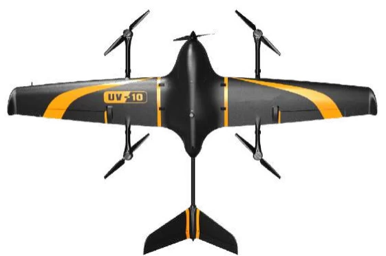
Electric VTOL fixed wing UAV-Aerial survey version
1. Features
|
Modularization Single lens camera/ Multi lens camera |
Intellectualization Fly mode according to terrain fluctuation |
|
Long endurance 100min flight time |
Security One-click take-off and landing |
|
Multi-redundant Multi-redundant navigation control system |
Simplification One-click data import |
|
High efficiency No ground phase control point, which can meet the surveying and mapping standard requirement of 1:500 |
High precision Real time differential technology based on 100HZ RTK |
2. Technical index
The fuselage of UAV
|
Texture of material |
EPP fuselage,Carbon fiber frame |
|
Wingspan |
220cm |
|
Length |
130cm |
|
Standard take-off weight & load |
6.7kg(with payload) |
|
Maximum flight time |
100min |
|
Mode of Take-off and landing |
Vertical take-off and landing |
|
Precision of recovery landing point |
<1m |
|
Promotion mode |
Electric compound wing forward pull propulsion |
|
Flight speed |
70km/h |
|
Maximum control radius |
10km |
|
Wind resistance |
Level 6 |
|
Altitude of departure point |
Above 4000 meters |
|
Operating temperature |
-20℃-45℃ |
GNSS
|
Channel number |
226 channel |
|
Signal tracking |
GPS L1 C/A, L2C,L2P(y),GLONASS L1/L2, GALILEO E1 |
|
The update frequency of RTK |
100HZ
|
|
The accuracy of RTK |
Horizontal:10mm+1.0ppm,vertical: 15mm+1.0ppm |
3. Survey Process Software
Route planning
Automatic flight path planning;Rich flight path types
Strip route: Suitable for road, river, power, pipeline, etc
Polygonal route: suitable for large area conventional flight missions

4. Application scenarios
|
Land |
UAV drone for sale,UAV surveying and mapping plays an important role in the field of land surveying and mapping because of its flexibility. Through the rapid acquisition of mapping UAV aerial photography data, we can quickly grasp the details of the survey area, which can be applied to land and resources dynamic monitoring and investigation, land use and coverage map updating, land use dynamic change monitoring, feature information analysis, etc. high resolution aerial images can also be applied to regional planning, etc. |
|
Route selection |
Remote sensing UAV can be applied to power line selection, highway line selection, railway line selection and oil line selection. It can quickly obtain the aerial image of linear UAV and provide design data for line selection according to the needs of the project. In addition, remote sensing UAV can also carry out line selection design and comprehensive monitoring for oil and gas pipelines. Centimeter level aerial images and high-definition video can assist in safety monitoring and management. At the same time, pipeline pressure data combined with images can be used to detect pipeline leakage, theft and other phenomena. |
|
Environment |
Efficient and fast acquisition of high-resolution aerial images can monitor environmental pollution in time, especially in the aspect of sewage pollution. In addition, marine monitoring, oil spill monitoring, water quality monitoring, wetland monitoring, solid pollutant monitoring, coastal zone monitoring, vegetation ecology and other aspects can be implemented with the help of aerial image or video data taken by remote sensing UAV. Among them, water quality investigation and monitoring, pollutant monitoring, atmospheric environment monitoring, solid waste detection and straw burning prohibition monitoring are the main application directions. |
|
Emergency |
UAV has been paid attention to in the field of Surveying and mapping, starting from the emergency relief. Whether it is Wenchuan earthquake, Yushu earthquake, Zhouqu debris flow, Ankang flood, mapping UAV arrived at the scene at the first time, and gave full play to the characteristics of mobility and flexibility to obtain the image data of the disaster area, which played an important role in disaster relief deployment and post disaster reconstruction. |
|
Agriculture and Forestry |
High resolution aerial images can provide accurate information of land texture and crop classification, and can be applied to agricultural land analysis, crop type recognition, crop growth analysis, soil moisture measurement, agricultural environment investigation, aquaculture area monitoring, forest fire monitoring, forest coverage analysis, forest vegetation health monitoring, forest storage assessment, etc. It can determine the planting area, growth status, growth stage and output value of specific agricultural crops, for example, it plays an important role in tobacco, agricultural Internet of things and other industries. |


