


- Browse Categories
- YQFH Drone
- DJI Drone
- Other Drone
- Drone Payloads
- Robot
- Pipeline Detection Instrument
- 3D Laser Scanner
- Industrial Measurement Devices
- Weather Station Series
- Optical Survey Instruments
- GNSS RTK & CORS System
- BDS System Products
- Visual Displacement Monitoring System
- UWB Indoor Positioning System
- Hydrology Products
- Others
- Spectrometer
- Wet Blast Machine
- SDI Soil Tester
- Pengjin Smart Flying Drone Patrol and Inspection System
- Supercomputing
- Module
- Viscometer
- Electric Hygro-thermograph
- Echo Sounder
- Processing Software
- Keson Measuring Tools
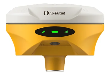

Better visual Stakeout Experience
– Visual positioning technology to find points with ease. The combination of virtual and reality by overlaying the design files with the real scene improves stakeout efficiency.
– Professional-grade starlight night vision HD camera with wide angle. Excellent performance and algorithm in tracking signals, achieving an accuracy of up to 1cm.
– Seamless switch of 360-degree AR stakeout between the handheld controller and the rover brings out immersive stakeout experiences making stakeout fast and accurate.
Built-in High-Precision Tilt Survey
– Based on the new generation of IMU, initialization occurs automatically at the startup without obtaining a fixed solution.
– Measure as reaching the point, efficient and convenient.
– Stable performance for reliable results.
Full Constellation and Full Frequency
– Advanced GNSS SoC chip features 1408 channels, supporting new frequency points B1C, B2a, and B2b RTK decoding for Beidou-3 Satellites.
– Multi-frequency interference detection technology and multi-stage adaptive filtering technology with a strong signal, good data, fast fixed procedure, and high accuracy.
Product Parameters
| Tilt Survey Accuracy | 8mm+0.7mm/°tilt |
| Channels | 1408/1760 |
| Signal tracking |
BDS/GPS/GLONASS/GALILEO/QZSS/NavlC/SBAS |
| Image Stakeout Accuracy | 1cm |
| Data Storage | Built-in 16GB ROM |
| Weight | ≤0.75kg |
Tel:+8613828792860
Wechat:PJK13828792860
Contact Person:Janet luo

- Other Products


