


- Browse Categories
- YQFH Drone
- DJI Drone
- Other Drone
- Drone Payloads
- Robot
- Pipeline Detection Instrument
- 3D Laser Scanner
- Industrial Measurement Devices
- Weather Station Series
- Optical Survey Instruments
- GNSS RTK & CORS System
- BDS System Products
- Visual Displacement Monitoring System
- UWB Indoor Positioning System
- Hydrology Products
- Others
- Spectrometer
- Wet Blast Machine
- SDI Soil Tester
- Pengjin Smart Flying Drone Patrol and Inspection System
- Supercomputing
- Module
- Viscometer
- Electric Hygro-thermograph
- Echo Sounder
- Processing Software
- Keson Measuring Tools
WR1010 High-Precision RTK Layout System – Intelligent Visual, Cost-Effective Choice
- Brand name:PJKt
- Model name: WR1010
- Origin: China
- Warranty period: 1 year
- Support Express: DHL UPS FedEx
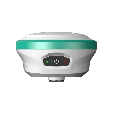
Intelligent Visual Layout RTK Measurement System WR1010
Features
|
Supper tracking capacity •Full-constellation,full-frequency,fixed fast •1408 channels,search and solve satellites up to 50+ •More sensitive signal reception,strong adaptive anti-interference |
Long distance of data transmission •Built-in 5W multi-protocol transceiver radio •Ultra long data link,15km long transmission •Super data link,base and rover switch at will |
|
|
4th generation IMU sensor •The newest IMU sensor makes the Tilt working more convenient,just a shake •Quick initialization for immediate measurement upon point selection |
High Protection and Reliability,Waterproof and Dustproof •Industrial-grade design with a magnesium alloy shell •IP68 certification for waterproof and dustproof |
|
|
AR guidance,lofting in place at once •Effective integration of navigation and visual •Real-time refresh of the handbook layout interface •Micro-light level camera for clearer image •Immersion lofting |
Specifications
| System Index | |
| Hardware System | Qualcomm Cortex-A7 |
| OS | Linux |
| GNSS Index | |
| Channel | 1408 |
| Signal Tracking |
GPS:L1 C/A、L1C、L2P (Y)、L2C、L5 GLONASS:L1、L2、L3 BDS:B1I、B2I、B3I、B1C、B2a、B2b GALILEO:E1、E5a、E5b、E6 QZSS:L1、L2、L5 SBAS:L1 NavIC (IRNSS)*: L5 |
| Data Format | NMEA-0183 |
| I/O Protocol | RTCM3.X |
| Update Rate | 20Hz max |
| Recapture Time | <1s |
| Cold Start Time | <40s |
| Single (RMS) |
Horizontal: 1.5m Vertical: 2.5m |
| DGPS (RMS) |
Horizontal: 0.4m Vertical: 0.8m |
| RTK (RMS) |
Horizontal: ±(8mm+1ppm) Vertical: ±(15mm+1ppm) |
| Time Accuracy (RMS) | 20ns |
| Static Accuracy (RMS) |
Horizontal: ±(2.5mm+1ppm) Vertical: ±(5mm+1ppm) |
| Speed Accuracy (RMS) | 0.03m/s |
| Tilt Compensation Accuracy | <2cm (up to 60°) |
| Communication Technical Index | |
| Network |
LTE FDD: B1/2/3/4/5/7/8/12/13/18/19/20/25/26/28 LTE TDD: B38/39/40/41 WCDMA: B1/2/4/5/6/8/19 GSM: B2/3/5/8 |
| Bluetooth | BR+EDR+BLE |
| WIFI | 802.11 b/g/n |
| Data Radio |
Frequency: 410~470MHz RF transmit power: 5W/1W Protocol: TRIMTALK, TRIMMK3, SOUTH, TRANSEOT Airborne baud rate: 9600, 19200 |
| Physical Index | |
| Materials | Magnesium alloy case +ABS/PC plastic top cover |
| Size | Φ140mm*85mm |
| Weight | ≤890g |
| Power | Power indicator |
| Satellite Light | Blinking indicates effective location |
| Data Link Light | Blink when there is differential data |
| Specification | 7.4V,6500mAh |
| Storage | 32GB |
| Camera | HD super wide-angle camera, support AR stakeout |
| Work Time |
More than 20 hours (manual network datalink mode) Continuous 26h data collection (full power, static mode) |
| Charge |
Support USB PD 15V/2A Support 5V/3A |
| Operating Temperature | -20℃~+60℃ |
| Storage Temperature | -20℃~+70℃ |
| Shock | Withstand 1.5m drop |
| Protection | IP68 |
| Attachment | |
| Host | 1 set |
| USB power adapter | 1 pcs |
| Type-C to Type-C | 1 pcs |
| Radio Antenna | 1 pcs |

- Other Products


